Antarctica 2008
Wednesday, December 5, 2007
It's almost three weeks since we got back from the last trip and
another one is in the works. After we retired, we had planned to do the
New Zealand trip and then a trip to Antarctica. However, the Antarctica
part fell through because by the time that we went to book it, the one
that we wanted was fully booked. It would have been on the sister ship
to the one that sank in Antarctica recently. Our next best choice was
way too expensive although it would have been a real down and dirty
trip with many stops on Antarctica itself and also on nearby
islands.
Then that Canadian ship hit some ice, rolled over and sank. Although
nobody was seriously hurt, the news apparently put a damper on
Antarctica cruise bookings because we got a last minute offer from
Princess that was hard to pass up. The 16 day cruise itself was
$999* per head for 16 days. The asterisk is important. So,
in less than two months after our last trip, we will be off again.
*The stated fare doesn't include taxes, air, transfers,
food or hotels before and after the cruise. The "extras" will easily
push the total cost to more than double that of the cruise itself.
Our cabin will again be an inside cabin. Inside cabins are
considerably less expensive, in this case, $500/head less, and if one
wants to see what is going on outside, one can actually go outside.
However, this is also a "scenic cruise" which basically means that we
don't get off the ship in Antarctica proper. A cabin with a veranda
would be nice to be able to see what is going by without having to go
out on deck and get blown away by a freezing wind but these are even
more expensive than a regular outside cabin. This can be a problem for
folks with limited mobility. Sandy and I are in good health and walking
around outside is not a big deal. We've got warm clothing suitable for
freezing conditions and wind.
| Star Princess |
Star Princess Specifications
|
 |
| Decks |
18 |
| Passenger Elevators |
14 |
| Passengers |
2600 |
| Crew |
1150 |
| Gross Tonnage (based on volume) |
109,000 |
| Net Tonnage (displacement) |
71,763 |
| Length |
951 ft |
| Width |
118 ft |
| Draft |
27.7 ft |
|
| Built |
2002 |
| Bow Thrusters |
3 units, 2992 bhp |
| Stern Thrusters |
3 units, 2334 bhp |
| Props |
2 x 6 blades |
| Main Diesel Engines |
4 x 11.5 MW
(14,500 bhp)
2 x 8.6 MW
(11,300 bhp) |
| Cruising Speed |
22.5 knots |
|
Our itinerary is:
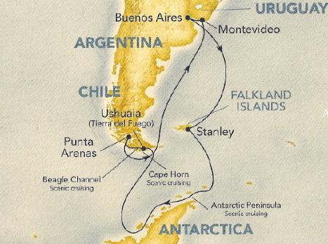 |
| Day |
Date |
Port of Call |
| Day 1 |
7 Jan 08 |
Leave LAX for O'Hare at 1025, arrive 1635
depart for Buenos Aires at 2230 |
| Day 2 |
8 Jan 08 |
Arrive, Buenos Aires, Argentina, sleep |
| Day 3 |
9 Jan 08 |
Check in, Buenos Aires, Argentina |
| Day 4 |
10 Jan 08 |
Embark, Buenos Aires, Argentina |
| Day 5 |
11 Jan 08 |
At Sea |
| Day 6 |
12 Jan 08 |
At Sea |
| Day 7 |
13 Jan 08 |
Falkland Islands (Port Stanley) |
| Day 8 |
14 Jan 08 |
At Sea |
| Day 9 |
15 Jan 08 |
Scenic Cruising, Elephant Island |
| Day 10 |
16 Jan 08 |
Scenic Cruising, Iceberg Alley and Admiralty Bay |
| Day 11 |
17 Jan 08 |
Scenic Cruising, Gerlache Strait and Neumaier Channel |
| Day 12 |
18 Jan 08 |
Scenic Cruising, Deception Island |
| Day 13 |
19 Jan 08 |
At Sea most of the day then Scenic Cruising at Cape Horn |
| Day 14 |
20 Jan 08 |
Ushuaia, Argentina |
| Day 15 |
21 Jan 08 |
Punta Arenas, Chile |
| Day 16 |
22 Jan 08 |
At Sea |
| Day 17 |
23 Jan 08 |
At Sea |
| Day 18 |
24 Jan 08 |
At Sea |
| Day 19 |
25 Jan 08 |
Montevideo, Uruguay |
| Day 20 |
26 Jan 08 |
Disembark, Buenos Aries, Argentina |
| Day 21 |
27 Jan 08 |
Depart, Buenos Aries, Argentina for O'Hare at 2050 |
| Day 22 |
28 Jan 08 |
Depart O'Hare at 0655 for LAX, arrive at 0925 |
|
Star Princess Deck Plans
Decks 14 thru 18
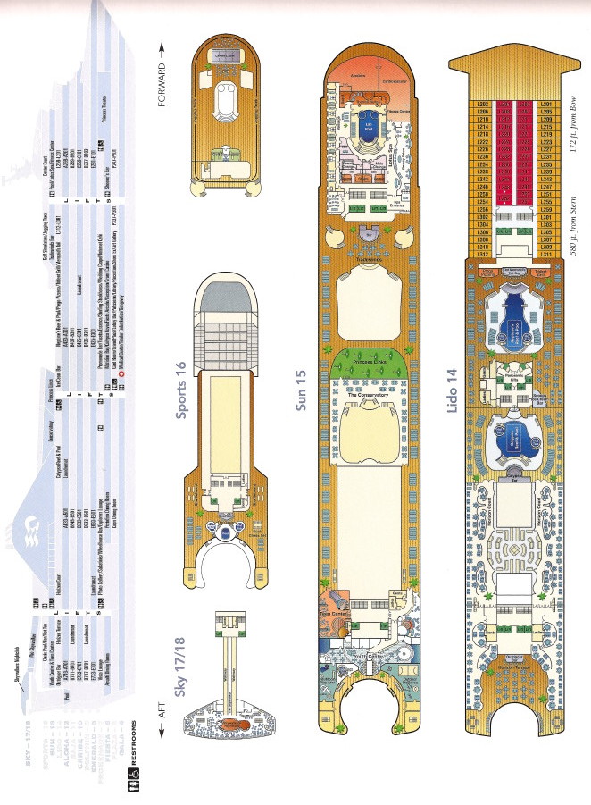
Decks 9 thru 12
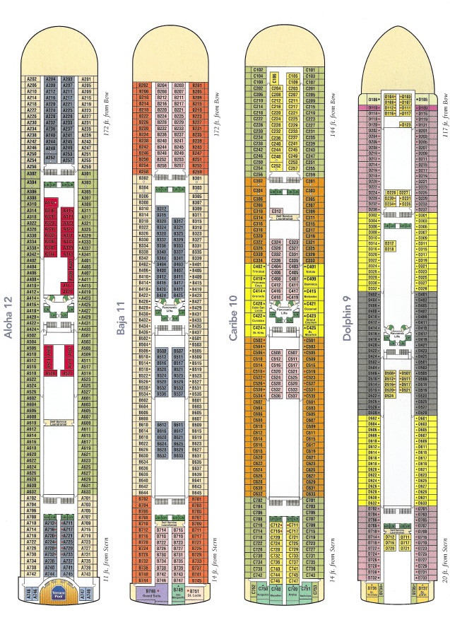
Decks 4 thru 8
Saturday, December 29, 2007
We got our cruise documents last week but we couldn't do the on-line
check in because our passports expired 5 days BEFORE SIX MONTHS after
the end of the cruise. It seems that the expiration date on a passport
is a misnomer. They become ineffective 6 months before that. In any
event, we got an appointment at the passport office in the Federal
building in Westwood yesterday and signed up to renew our passports.
We'll get the new ones with the RFID tag imbedded inside. Katie gave us
"tinfoil hats" for our passports for Christmas. These are shielded
folders that will make it much harder for someone to scan and read our
passports without our knowledge. I have to drive back up there on
January 2nd to pick them up.
We have our flights and hotels lined up, warm clothes packed and are
basically ready to go. We actually leave on the 7th on a red-eye so
that we get there on the morning of the 8th, 2 days early. This is to
cover last minute delays or flight cancellations. We're supposed to
check in at our hotel the afternoon of the 8th.
Friday, January 4, 2008
Our flights to and from Buenos Aires are through O'Hare. The flights
to Buenos Aires are red eyes, we'll be on the airplane all night...
fun. We'll be staying in PanAmericano hotel in Buenos Aires both before
and after the cruise.
Day 1, Monday Jan 7, 2008 about 0900 PST, Los Angeles
It's started, we're at LAX waiting for our flight. We've still go an
hour and a half to wait. Security was the usual hassle but we made it
through. Terminal 4 is built without AC outlets that are accessible to
passengers so I'm running on one of two weak batteries. The other is
packed in a plastic bag per the new TSA rules.
Update, Day 1, Monday Jan 7, 2008 about 2100 CST, Chicago
We've made it to Chicago and are waiting for our next flight, but it
wasn't smooth. Apparently the winds at O'Hare were too high and the
number of flights allowed to land were restricted. Inbound flights were
held at their departing airports, which for us, was LAX. They boarded
our flight a half hour late and then immediately unboarded it because
of a 2 hour delay. We elected to stay on the plane because the seats
were actually more conformable than in the waiting area at LAX.
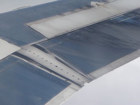 My seat was behind the wing on the right side. I
noticed something dripping from the flap when we were on the ground,
but I didn't pay much attention to it because I thought it was water.
However, as we got to altitude, it didn't freeze. There was a row of
droplets hanging on the trailing edge of one of the flaps that
glistened in the sun, which was behind us. The fuel on the trailing
edge was a lot easier to see than in this photo, but it can be seen.
Then I realized that it was fuel. Eventually, I could see a film of
fuel (slightly darker streak on the lower left of the top darker panel)
leading back from the fuel filler port on the wing and eventually
terminating on the flap. I informed the crew and the stewardess called
the cockpit. They didn't seemed too concerned, but I was. Eventually,
the flow reduced, probably as a result of fuel being consumed causing
the fuel level in the tank to drop below the level of the leak.
My seat was behind the wing on the right side. I
noticed something dripping from the flap when we were on the ground,
but I didn't pay much attention to it because I thought it was water.
However, as we got to altitude, it didn't freeze. There was a row of
droplets hanging on the trailing edge of one of the flaps that
glistened in the sun, which was behind us. The fuel on the trailing
edge was a lot easier to see than in this photo, but it can be seen.
Then I realized that it was fuel. Eventually, I could see a film of
fuel (slightly darker streak on the lower left of the top darker panel)
leading back from the fuel filler port on the wing and eventually
terminating on the flap. I informed the crew and the stewardess called
the cockpit. They didn't seemed too concerned, but I was. Eventually,
the flow reduced, probably as a result of fuel being consumed causing
the fuel level in the tank to drop below the level of the leak.
We had a 4 hour layover originally scheduled in Chicago, but since
we got in 2-1/2 hours late, I expected that we would still have enough
time to make our next flight. When we got there, we found that our
flight was leaving from the next door gate, but it was an hour late
too, so our layover was still 2-1/2 hours.
Except that the next time I looked, the flight was going to be 2
hours late. Then a little later, it was 2-1/2 hours late AND there
wasn't going to be any meals on an 11 hour flight. We wandered off to
the food court to get some dinner. By the time we got back, the flight
was scheduled 3 hours late. We might consider walking to Buenos Aires,
we might get there sooner.
Update, Day 2, Tuesday Jan 8, 2008 about 2100 GMT-2, Buenos
Aires
 The flight to Buenos Aires was long but
otherwise uneventful. It was about 100°F outside at the airport but
it was a little cooler in town. We are staying at the PanAmericano
Hotel in downtown Buenos Aires. In a little bit, we'll venture out to
see what is in the vicinity of the hotel and find some food. They
actually did feed us on the airplane, even though the sign as the gate
said that they would not. I got very little sleep so I am seriously
sleep deprived now, but I'm not sleepy, just a little buzzed.
The flight to Buenos Aires was long but
otherwise uneventful. It was about 100°F outside at the airport but
it was a little cooler in town. We are staying at the PanAmericano
Hotel in downtown Buenos Aires. In a little bit, we'll venture out to
see what is in the vicinity of the hotel and find some food. They
actually did feed us on the airplane, even though the sign as the gate
said that they would not. I got very little sleep so I am seriously
sleep deprived now, but I'm not sleepy, just a little buzzed.
They booked us into a "Suite Presidencial" for no extra charge
beyond the $145US that the room costs. However, the sign on the inside
of the door says that the room books for $551US. I've been in some
pretty nice hotel rooms recently, but this is the nicest yet. Internet
costs $12US for 24 hours with in room wireless.
 I've got the PowerBook this time
and it is set up with a USB hub recharging all the stuff that I
flattened on the trip here. The power brick for the PowerBook and the
wall wart for the USB hub are plugged into an AC gender bender. The
whole mess is propped on the coffee maker so that it doesn't fall out
of the wall outlet.
I've got the PowerBook this time
and it is set up with a USB hub recharging all the stuff that I
flattened on the trip here. The power brick for the PowerBook and the
wall wart for the USB hub are plugged into an AC gender bender. The
whole mess is propped on the coffee maker so that it doesn't fall out
of the wall outlet.
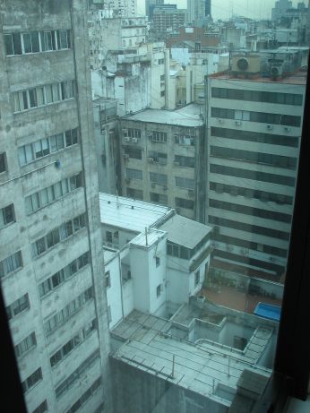 The view out of our window isn't so
"Presidencial." This is the side that only the locals typically see.
the little pool in the lower part of the photo was a playspot for a
party of late night, nude, and mixed sex swimmers.
The view out of our window isn't so
"Presidencial." This is the side that only the locals typically see.
the little pool in the lower part of the photo was a playspot for a
party of late night, nude, and mixed sex swimmers.
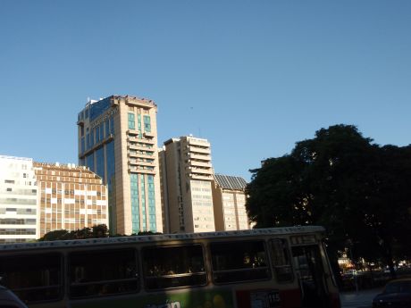
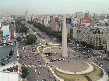 We took the elevator up to the 23rd floor
of the hotel to take some pictures. This is what downtown Buenos Aires
looks like. The very wide street is Avenue 9 de Julio. There is a
obelisk monument there for something, I couldn't figure out what is is
because I don't read Spanish very well. The whole area is very flat so
that there are radio towers planted everywhere.
We took the elevator up to the 23rd floor
of the hotel to take some pictures. This is what downtown Buenos Aires
looks like. The very wide street is Avenue 9 de Julio. There is a
obelisk monument there for something, I couldn't figure out what is is
because I don't read Spanish very well. The whole area is very flat so
that there are radio towers planted everywhere.
After watching the traffic on Avenue 9 de Julio for awhile, I
noticed how ordered it was. Nobody was speeding or tailgating. There
were no horns at all. Some drivers seem to like to split lanes for
extended periods, our taxi driver did this a lot on the way in. I'm not
sure why, but it seems to be fairly common here.
We found out later, however, that pedestrians are fair game. The
locals have no qualms about crossing streets with traffic flowing and
drivers seem to ignore them. Everybody knows the "rules" and nobody
gets hurt. However, if you want to walk like a local, you have to be
quick.
The sidewalks are in terrible shape with lots of changes in level,
loose sidewalk tiles and outright holes. A public sidewalk like these
in the US would be an instant lawsuit.
It's 2100 now and the sun hasn't gone down yet as this is the
beginning of the summer and Argentina is on Daylight Savings Time.
Update, Day 3, Wednesday Jan 9, 2008 about 2100 GMT-2, Buenos
Aires
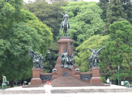 We slept in this morning in an attempt to
deal with accumulated sleep deprivation, it worked. We'd bought some
munchies yesterday for breakfast today, but we went out on a walk
before lunch. This time, we went north on Avenue 9 de Julio and then
turned east toward the port area. We went as far as the Plaza
Libertador Gral. San Martin. General San
Martin is the father of modern Argentina. On the way back to the
hotel, we found a bakery with excellent food for reasonable prices, we
got lunch for both of us (a small pizza, a large sandwich and some
other stuff) for about $4US. This was a take out place so we went back
to the hotel to eat and rest.
We slept in this morning in an attempt to
deal with accumulated sleep deprivation, it worked. We'd bought some
munchies yesterday for breakfast today, but we went out on a walk
before lunch. This time, we went north on Avenue 9 de Julio and then
turned east toward the port area. We went as far as the Plaza
Libertador Gral. San Martin. General San
Martin is the father of modern Argentina. On the way back to the
hotel, we found a bakery with excellent food for reasonable prices, we
got lunch for both of us (a small pizza, a large sandwich and some
other stuff) for about $4US. This was a take out place so we went back
to the hotel to eat and rest.
I really thought that I had caught up on my sleep, but after lunch
Sandy crashed. After an hour or I laid down to rest a bit and it was
1700 before I woke up again. By that time, it was time to go downstairs
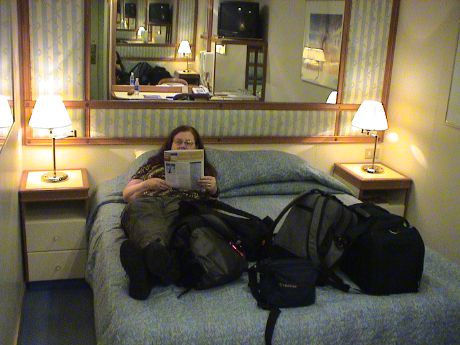
and check in. Our cabin is B217 on Deck 11, an inside cabin on the
starboard side, about 4 cabins back from the bow.
The check in process was chaotic and disorganized. They gave us a
number and told us to come back in an hour. We did and then waited over
another hour. I think that we've got the instructions straight and have
the map marked properly so that we can get there between 1300 and 1500
tomorrow.
Day 4, Thursday Jan 10, 2008 about 1600 GMT-2, Buenos Aires
 We've made it onto the ship. This is our home
for the next 16 days. Sandy was reading the tour excursion booklet and
found that many of the tours that she wants are booked up already so
she's gone to the shore excursion office to see what she can get.
We've made it onto the ship. This is our home
for the next 16 days. Sandy was reading the tour excursion booklet and
found that many of the tours that she wants are booked up already so
she's gone to the shore excursion office to see what she can get.
Our cabin is an inside cabin again as we didn't pay the substantial
premium for an outside cabin. However it is nice enough.
We got lunch right after we got on board and then took an
introductory tour of the ship. This is a very big ship, probably 50%
bigger than the largest ship we've been on before. There are 18
numbered decks. The highest is a bar way above the ship's stern. In
profile, this bar makes the ship look like it has a very large spoiler.
There are at least four several swimming pools. We have "anytime"
dining so we can eat when we please. I don't have the ship's
specifications yet, I'll see if I can get something when the trauma of
embarkation dies down.
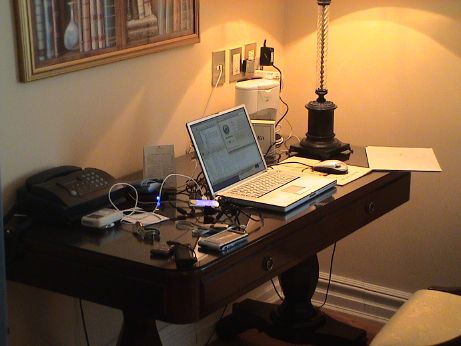
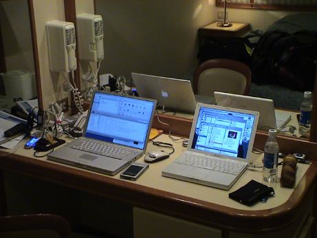 The room has a reasonably sized desk that
we've set up as a computer center. There is wireless internet on the
ship for $0.50/min ala carte, but I can't sign up for it yet. The
internet description says that the satellite link may be intermittent
and we will NOT get broadband speeds. We are used to this on cruise
ships. However, I expect the link to be VERY intermittent, as in not
working for days at a time, because of the very far southern latitudes
in which we will be sailing. Geosync satellite coverage near the poles
is poor at best. I was able to sign up with little difficulty or you
wouldn't be reading this.
The room has a reasonably sized desk that
we've set up as a computer center. There is wireless internet on the
ship for $0.50/min ala carte, but I can't sign up for it yet. The
internet description says that the satellite link may be intermittent
and we will NOT get broadband speeds. We are used to this on cruise
ships. However, I expect the link to be VERY intermittent, as in not
working for days at a time, because of the very far southern latitudes
in which we will be sailing. Geosync satellite coverage near the poles
is poor at best. I was able to sign up with little difficulty or you
wouldn't be reading this.
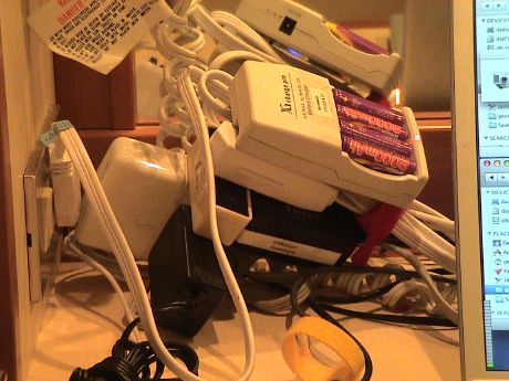 The
ship has 110 VAC only so we don't have to use the gender benders, but
we still have a real mess. There is a 3-way extension cord, and a 3 way
splitter powering the PowerBook charger, Sandy's iGo charger, the USB
hub brick, the iPod speaker brick and a battery charger. We used all
the sockets up, but almost everything we need is plugged in. The iGo
charger powers Sandy's iBook and charges (one at a time) her cell
phone, my video camera, my PDA, Sandy's PDA, and gives us another USB
charging port. The one thing not there is the charger for Sandy's
Olympus camera, but we can unplug the AA charger to plug that in.
The
ship has 110 VAC only so we don't have to use the gender benders, but
we still have a real mess. There is a 3-way extension cord, and a 3 way
splitter powering the PowerBook charger, Sandy's iGo charger, the USB
hub brick, the iPod speaker brick and a battery charger. We used all
the sockets up, but almost everything we need is plugged in. The iGo
charger powers Sandy's iBook and charges (one at a time) her cell
phone, my video camera, my PDA, Sandy's PDA, and gives us another USB
charging port. The one thing not there is the charger for Sandy's
Olympus camera, but we can unplug the AA charger to plug that in.
Update, Day 4, Thursday Jan 10, 2008 about 1900 GMT-2, Buenos
Aires
We've done the life jacket drill and the ship was supposed to have
sailed by now, but we're still at the dock due to some kind of
immigration problems. We went to the early dinner and that about did me
in because I got virtually zero sleep last night.
Our luggage finally arrived and we haven't lost anything that we
know about yet.
We didn't get the tour to the penguin rookeries outside of Port
Stanley in the Falkland Islands. We are on a wait list but it isn't
looking good.
Day 5, Friday Jan 11, 2008 about 0130 GMT-2, At Sea
 The time is right, it's 1:30 in the morning. I
am still totally jet lagged. I crashed shortly after dinner and woke up
at about midnight. We were both awake so we took a midnight stroll to
see what was going on at night. The answer, not very much. The Lido was
open with some food, mostly leftover dinner stuff. We went up the the
Skywalker Bar on deck 18 aft expecting to see some night life. No dice,
there were just four passengers in the bar.
The time is right, it's 1:30 in the morning. I
am still totally jet lagged. I crashed shortly after dinner and woke up
at about midnight. We were both awake so we took a midnight stroll to
see what was going on at night. The answer, not very much. The Lido was
open with some food, mostly leftover dinner stuff. We went up the the
Skywalker Bar on deck 18 aft expecting to see some night life. No dice,
there were just four passengers in the bar.
We are still on the River Plate. When we woke up, we could feel or
hear nothing that indicated that we were on a ship. Up in the bar, we
could feel some ship movement. After the walk, we picked up some ship
movement in our cabin too. We must be nearing the open ocean. Anyway,
it's back to bed to try to pick up the rest of the night's sleep.
Update, Day 5, Friday Jan 11, 2008 about 1230 GMT-2, At Sea
After our midnight stroll, we went back to bed an slept until 0930
or so. There were some announcements about a fire in a trash unit but
it was quickly extinguished. After breakfast, we went to the port
lecture for Stanley, Ushuaia and Punta Arenas. From there it was lunch
(brat and pizza).
The weather is very nice, a little cool, but clear, sunny and
smooth. There is a little perceptible ship motion, but not enough to
cause any difficulty at all. Sandy is planning on seeing a movie,
The Queen mid afternoon. I'll probably start my video ship tour.
However this is a big ship, twice as heavy as the ms Statendam, and
it'll take awhile.
Update, Day 5, Friday Jan 11, 2008 about 1630 GMT-2, At Sea
Sandy is back from the movie, I'm back from the video tour. I tried
to take a nap, but I didn't sleep even though I feel sleepy. Tonight is
formal night in the dining rooms, however, in an attempt to pack
lighter, neither Sandy or I brought formal clothing so we'll be eating
in the Horizon cafe on the Lido deck this evening. This is not a bad
thing as the food there is pretty good. There is a steakhouse on board,
but the cover charge is $15/head and in the Trattoria the cover is
$20/head. In all the other cruises that we have been on, dining seating
is assigned to a particular table at a particular time. On this cruise,
there are 3 main dining rooms, one has the traditional assigned
seating. The other two are "any time, any table" seating. The 2nd main
dining room is assigned to the early anytime seating, the 3rd main
dining room is for the later anytime seating. The apparent disadvantage
of anytime seating is that if you arrive near the beginning of the
seating time, there is a line waiting to get in.
This ship is built a little differently from others that we have
been on. First, it is really big, 2600 passengers, although there are
bigger ones afloat (3600 passengers) and MUCH bigger ones (6000
passengers) being built. The capacity of this ship is twice that of the
ms Statendam, at 1300 passengers and still much bigger than the largest
ship that we have sailed on, the ms Oosterdam, at 1812 passengers. On
the Star Princess, all 5 passenger decks (8 thru 12) are grouped
together with the public decks arranged above and below. This means
that we are going either upstairs or downstairs to go anywhere. On the
other ships, the decks were more layered with some public decks up
high, then a layer of passenger decks, then a layer of pubic decks
where the lifeboats are, then a few more layers of passenger decks.
When a ship this big enters a small port, it can overwhelm the
facilities of the port. This is the case in Stanley where the passenger
complement is larger than the population of the entire town. The tours
are limited in size simply because there aren't facilities available to
cover everybody. There are only 9 taxies in the whole place. This is
why all the penguin rookery tours were booked solid before the ship
even left port. Our cruise is called a "scenic cruise" because we don't
actually set foot in Antarctica and many other places, we only cruise
by to look at the scenery from a safe distance. The cruises that
actually let people go ashore in the small places are on much smaller
ships, maybe 50 to 150 passengers per ship. Even the 800 passenger
ships have to limit the shore time to an hour per passenger to allow
everybody to go ashore. Because of the economies of scale, which the
smaller ships cannot take advantage of, cruising on a small ship is
much more expensive than on a huge ship like this one. However, the
experience is MUCH more up close and personal. If we like what we see
here, we may elect to come back for a much more detailed look.
Day 6, Saturday Jan 12, 2008 about 0130 GMT-2, At Sea
Yep, it's 0-dark-30 again and we're up again. I haven't yet gone to
sleep tonight. We went upstairs again for a snack. The ship has hit
some pretty heavy seas and we're pitching pretty heavily. The ship is
banging and groaning more than on any other cruise that we've been on.
It's also become much cooler than it was last night.
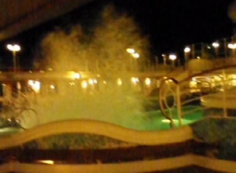 As we were walking back
from the cafe, the water in the two large pools was sloshing really
well. When the period of the swells matched the wave resonance of the
pools, we got some pretty big splashes. Sandy caught a few of them on
her little camera. It's not the best quality video, but it gets the
message across. The photo is actually a link to a short video. You'll need either QuickTime or
some other codec that can decode H.264 video to view this movie.
As we were walking back
from the cafe, the water in the two large pools was sloshing really
well. When the period of the swells matched the wave resonance of the
pools, we got some pretty big splashes. Sandy caught a few of them on
her little camera. It's not the best quality video, but it gets the
message across. The photo is actually a link to a short video. You'll need either QuickTime or
some other codec that can decode H.264 video to view this movie.
If you don't like things that go bump in the night, then you
probably won't get along with cruise ships. As the ships move around
with the swells, they bang, creak and groan. Coat hangers bang around
in the closets. There is traffic in the hallways. Even though the
staterooms are pretty well sound insulated, some sounds from adjacent
rooms can be heard. I find the movement at night soothing, after we got
back from our midnight excursion, the ship was bouncing pretty good,
but I was rocked right back to sleep.
Update, Day 6, Saturday Jan 12, 2008 about 1330 GMT-2, At Sea
 I
was cruising around the ship looking for nooks and crannies that I
hadn't found before and I saw two albatross weaving back and forth
across our wake. I expect that they were looking for anything edible
that surfaced in the turbulence. Although I watched them for awhile, I
never saw either one hit the surface.
I
was cruising around the ship looking for nooks and crannies that I
hadn't found before and I saw two albatross weaving back and forth
across our wake. I expect that they were looking for anything edible
that surfaced in the turbulence. Although I watched them for awhile, I
never saw either one hit the surface.
Day 7, Sunday Jan 13, 2008 about 1600 GMT-3, Stanley, Falkland
Islands
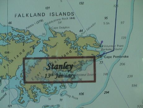 We've made it to the Falkland Islands in the
South Atlantic ocean. It took two days to get here. We're told that
yesterday, two cruise ships could not even get into the harbor due high
winds. Today, the weather was very nice indeed, about as good at it
gets.
We've made it to the Falkland Islands in the
South Atlantic ocean. It took two days to get here. We're told that
yesterday, two cruise ships could not even get into the harbor due high
winds. Today, the weather was very nice indeed, about as good at it
gets.
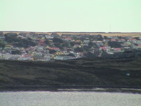 This is Port Stanley, now called just Stanley. I
am on the highest deck of the ship looking over a headland into the
port. The lowest row of buildings are right at the waterfront. This is
pretty much what the whole town looks like, a few streets worth of
buildings built up from the shore of Stanley Harbor.
This is Port Stanley, now called just Stanley. I
am on the highest deck of the ship looking over a headland into the
port. The lowest row of buildings are right at the waterfront. This is
pretty much what the whole town looks like, a few streets worth of
buildings built up from the shore of Stanley Harbor.
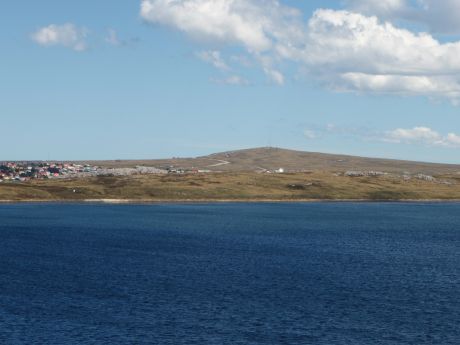 This picture of one edge of the town. The town
extends along a hillside and ends abruptly. There are a few structures
past the last row of houses, then nothing.
This picture of one edge of the town. The town
extends along a hillside and ends abruptly. There are a few structures
past the last row of houses, then nothing.
The Falkland Islands are a hardscrabble place where the living has
been hard too. However, since the Falklands conflict, there has been an
infusion of capital and new sources of income. They say it wasn't a war
because war was never declared. Still over 1000 young men on both sides
died, it probably seemed like a war to their families. In any event,
the economy of the Falklands depends on sheep (there are 6 million
sheep here), fishing and tourism. About 85,000 tourists a year visit
the Falklands, mostly from cruise ships.
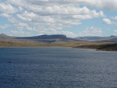 Extending past the edge of the last photo
is the typical view of an undeveloped area. Due to the poor soil, high
winds and generally bad weather, not much grows here. If an area is
left to itself, this is what happens. However, the weather today was
outstanding. We left the ship braced for cold and rain, but the sun
came out, the clouds parted, it warmed to maybe 65°F and the wind
died. One of the drivers commented that we should come back more often
if we bring weather like this. Apparently, the weather today is far
from normal.
Extending past the edge of the last photo
is the typical view of an undeveloped area. Due to the poor soil, high
winds and generally bad weather, not much grows here. If an area is
left to itself, this is what happens. However, the weather today was
outstanding. We left the ship braced for cold and rain, but the sun
came out, the clouds parted, it warmed to maybe 65°F and the wind
died. One of the drivers commented that we should come back more often
if we bring weather like this. Apparently, the weather today is far
from normal.
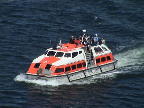 Stanley
Harbor is too small for this monster ship to get into, so we moored in
the outer harbor. To get to the jetty in town, we use a tender like
this one. It holds about 80 people and doubles as a lifeboat. Tenders
are a pain because everybody wants to get off the ship at the same time
at every tender port and it can take awhile to get ashore.
Stanley
Harbor is too small for this monster ship to get into, so we moored in
the outer harbor. To get to the jetty in town, we use a tender like
this one. It holds about 80 people and doubles as a lifeboat. Tenders
are a pain because everybody wants to get off the ship at the same time
at every tender port and it can take awhile to get ashore.
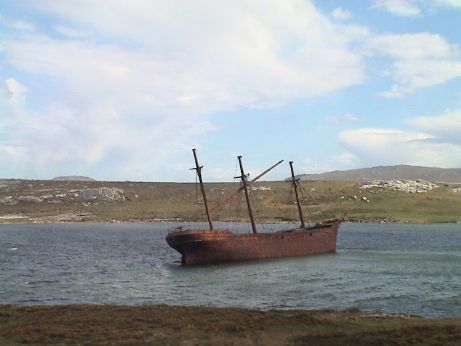 All
the ship's tours to the penguin rookeries were booked up long before
the cruise started. However, from Stanley, there is a shuttle bus to
Gypsy Cove for $10/head round trip. It's only about 4 miles out of town
and it turns out that it is right near where the ship moored. Along the
way, we saw the wreck of the Lady Elizabeth which hit a rock in 1913
and was deemed to be unseaworthy so it was scuttled in the bay. The
port contains some 20 shipwrecks, mostly of sailing ships that were
dismasted around Cape Horn and limped into Port Stanley where they were
abandoned.
All
the ship's tours to the penguin rookeries were booked up long before
the cruise started. However, from Stanley, there is a shuttle bus to
Gypsy Cove for $10/head round trip. It's only about 4 miles out of town
and it turns out that it is right near where the ship moored. Along the
way, we saw the wreck of the Lady Elizabeth which hit a rock in 1913
and was deemed to be unseaworthy so it was scuttled in the bay. The
port contains some 20 shipwrecks, mostly of sailing ships that were
dismasted around Cape Horn and limped into Port Stanley where they were
abandoned.
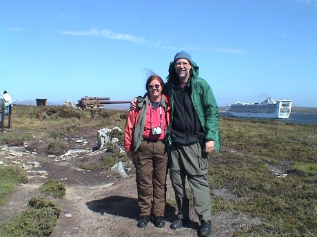 At the end of the trail at Gypsy Cove is
Ordinance Point. This is a WWII coastal defense gun, seeming to be
pointing at the Star Princess. Another tourist took this picture of
Sandy and myself with my camera.
At the end of the trail at Gypsy Cove is
Ordinance Point. This is a WWII coastal defense gun, seeming to be
pointing at the Star Princess. Another tourist took this picture of
Sandy and myself with my camera.
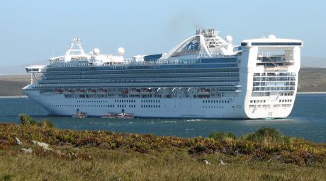 This is the first spot where we
could actually get our own pictures of the Star Princess. This is a
really big ship, perhaps too big. The 2600 passengers that the ship
disgorges more than doubles the population of an out of the way place
like Stanley. The locals appreciate the boatloads of money that arrives
with these ships, but it comes too fast and the facilities of these
small ports are easily overwhelmed.
This is the first spot where we
could actually get our own pictures of the Star Princess. This is a
really big ship, perhaps too big. The 2600 passengers that the ship
disgorges more than doubles the population of an out of the way place
like Stanley. The locals appreciate the boatloads of money that arrives
with these ships, but it comes too fast and the facilities of these
small ports are easily overwhelmed.
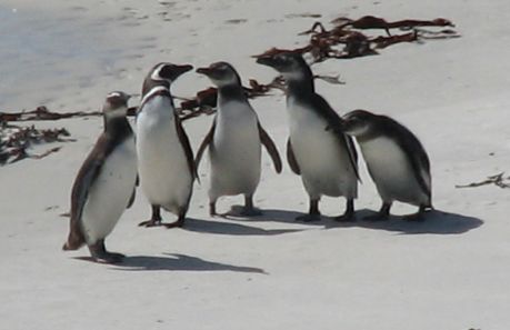
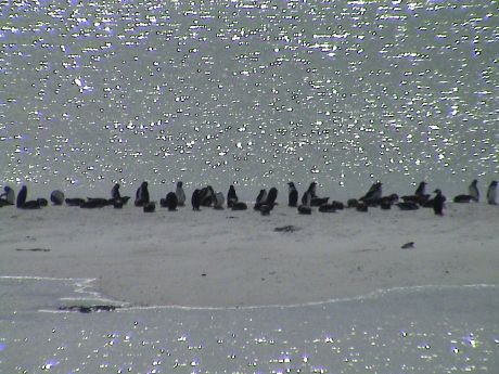 However, we didn't take the bus to see our ship, we
came to see some penguins. Gypsy Cove is one of the few rookeries that
is not on private land and it is close to Stanley so that a shuttle
service can handle lots of visitors. The penguins are a couple of
hundred yards away from the trail. However, there were lots of them
there.
However, we didn't take the bus to see our ship, we
came to see some penguins. Gypsy Cove is one of the few rookeries that
is not on private land and it is close to Stanley so that a shuttle
service can handle lots of visitors. The penguins are a couple of
hundred yards away from the trail. However, there were lots of them
there.
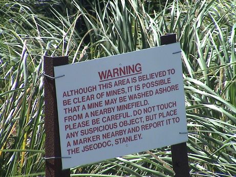 This is what keeps people on the trails.
Although the mines are supposed to have been cleared, no right thinking
person is going to hop the short fence for a closer look. There were
lots of folks there that either could not read english, or were pretty
stupid because some of them were tramping around through the bush
anyway. Nobody got blown up that we know about. We're told that there
have been no civilian casualties to landmines since the conflict, but I
certainly wasn't planning on being the first.
This is what keeps people on the trails.
Although the mines are supposed to have been cleared, no right thinking
person is going to hop the short fence for a closer look. There were
lots of folks there that either could not read english, or were pretty
stupid because some of them were tramping around through the bush
anyway. Nobody got blown up that we know about. We're told that there
have been no civilian casualties to landmines since the conflict, but I
certainly wasn't planning on being the first.
 Even though the penguins were far away, Sandy
discovered that the "super zoom" feature of her Cannon S2 IS worked
pretty well. She got lots of pics like this at 200 yards or so.
Even though the penguins were far away, Sandy
discovered that the "super zoom" feature of her Cannon S2 IS worked
pretty well. She got lots of pics like this at 200 yards or so.
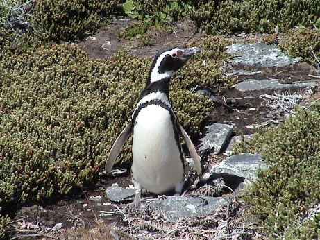 Magellanic Penguins, the ones
in this colony, dig their nests in burrows. This one climbed the hill
from the beach and came right up close so we could take good pictures.
Last seen, he or she was climbing all around through the low vegetation
in search of something. The photo is a link to a short movie of this penguin.
Magellanic Penguins, the ones
in this colony, dig their nests in burrows. This one climbed the hill
from the beach and came right up close so we could take good pictures.
Last seen, he or she was climbing all around through the low vegetation
in search of something. The photo is a link to a short movie of this penguin.
There was another with a nest about 4 feet from the edge of the
trail. The mother penguin was just lying down in front of the nest
containing two large chicks. She didn't move in the two hours or so
that we were there.
After the trip to Gypsy Cove, we walked through a small part of
Stanley, visited a couple of gift shops and headed back to the ship as
Sandy's knee was bothering her and she didn't want to injure it.
As I was writing the section on the Falklands, I got to thinking
more about how big this ship is, and it's not even the biggest around.
What good is a ship this large anyway? What does it have that smaller
ships don't? IMHO, the answer is, not much. Ok, there are three main
dining rooms instead of one, but how many times can you eat dinner at
once? There are five major swimming pools, several smaller ones and a
boatload of hot tubs. How many different pools can you really use?
True, there is a tennis court and a 9 hole miniature golf course (which
could be really fun with the ship rolling all around) but overall,
there is just more of the same, not more different things. From the
passenger's perspective, this huge ship don't do anything but cram more
people on the boat. The tender services have to handle more people at
once, the smaller ports have to handle more people all at once. This
just leads to bottlenecks and overcrowding. When a ship gets too small,
it can be really tossed around by a rough sea. But the 1500 passenger
ships are easily large enough so that they will ride as well as even
larger ships. The smaller ships can get into ports that the larger ones
cannot. For example, this ship cannot get through the Panama Canal, it
is about 13 feet too wide.
From the cruise lines point of view, the economies of scale may work
in their favor when the cruise destinations can support that kind of
traffic, but I don't see how the mega-ships help the passengers at
all.
Day 8, Monday Jan 14, 2008 about 1300 GMT-2, At Sea
The trip south from Stanley has been smooth and quiet except that
it's become noticeably colder and it was raining when we finally rolled
out of bed for breakfast at about 1000. I have finally managed to
adjust my body clock and am sleeping normally now.
As the ship goes further south we will probably lose the internet
coverage at some point. We'll be cruising along the Antarctic Peninsula
and the Drake Passage for 4 days, this is the most likely place to lose
the satellite link to the internet.
I sat in on part of a naturalist talk on Antarctica just before the
culinary arts demo and kitchen tour. When I got back to the cabin,
Sandy was nowhere to be found. This is such a large ship that wandering
around looking for her is pretty much a lost cause. I could do it by
skipping anywhere that is cold, but we'll connect again soon
anyway.
The Princess Lines corporate executive chef is on board and he gave
the demo. He cooked up some pasta with pesto sauce that looked really
good. Then he prepared some ratatouille with scallops and finally some
ice cream dish that was mostly eggs and whipped cream. It looked like
it could kill in one serving just from the calorie count.
The handout that they provided listed the amount of raw food that
the ship consumes each day for the passengers, it's a pretty big
shopping list. Then there's the crew.....
Star Princess Daily Food Consumption
| Food Type |
Quantity |
Unit |
| Fish |
1,500 |
lbs |
| Poultry |
1,800 |
lbs |
| Beef |
2,100 |
lbs |
| Pork/Pork Products |
1,000 |
lbs |
| Veal |
400 |
unit |
| Lamb |
460 |
lbs |
| Salads |
1,600 |
lbs |
| Shrimps |
300 |
lbs |
| Mayonnaise |
28 |
gal |
| Sandwiches |
1,500 |
ea |
| Pastas |
500 |
lbs |
|
| Food Type |
Quantity |
Unit |
| Potatoes |
2,000 |
lbs |
| Vegetables |
2,500 |
lbs |
| Soups |
550 |
gal |
| Flour |
1,700 |
lbs |
| Pastries |
6,000 |
ea |
| Ice Cream |
90 |
gal |
| Cakes and Pies |
300 |
ea |
| Butter |
500 |
lbs |
| Fresh Fruit |
7,000 |
lbs |
| Coffee |
470 |
gal |
| Cream |
62 |
gal |
| Sugar |
400 |
lbs |
|
Day 9, Tuesday Jan 15, 2008 about 1600 GMT-2, Elephant Island,
about 60° South
 This morning we came along side
Elephant Island well off the north end of the Antarctic Peninsula. This
is where the Shackleton Expedition over wintered on the way back from
their expedition to the South Pole. They stayed here for a year before
they could return to England. A ship's crew member snapped this picture
for me.
This morning we came along side
Elephant Island well off the north end of the Antarctic Peninsula. This
is where the Shackleton Expedition over wintered on the way back from
their expedition to the South Pole. They stayed here for a year before
they could return to England. A ship's crew member snapped this picture
for me.
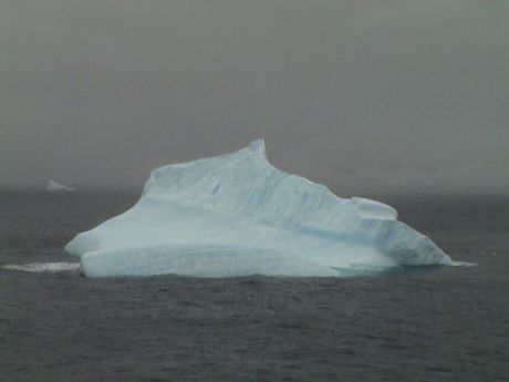
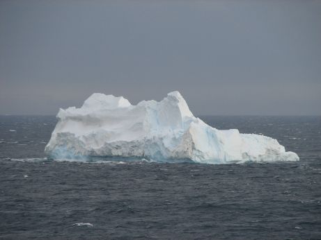
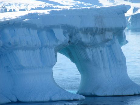
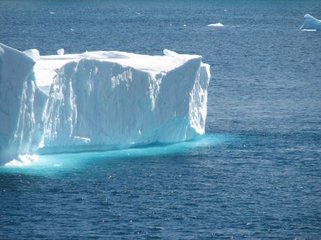
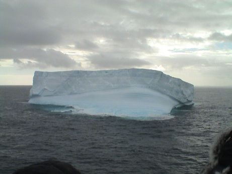 This is an iceberg formed from an ice
shelf. It is pretty easy to determine the source because of the flat
top. Icebergs that break off a glacier are typically oddly shaped and
ones formed from sea ice have long melted and wouldn't be anywhere near
this thick. It's hard to get the scale from the picture, but the broken
edges are probably more than 30 feet high.
This is an iceberg formed from an ice
shelf. It is pretty easy to determine the source because of the flat
top. Icebergs that break off a glacier are typically oddly shaped and
ones formed from sea ice have long melted and wouldn't be anywhere near
this thick. It's hard to get the scale from the picture, but the broken
edges are probably more than 30 feet high.
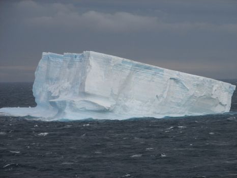
 This is another iceberg with
some interesting layering. It is hard to say where this one came from
and it has probably overturned several times.
This is another iceberg with
some interesting layering. It is hard to say where this one came from
and it has probably overturned several times.
It was about freezing during the time that were by Elephant Island.
I was warm enough but if it gets much colder, I'll have to put on
another layer. It's nice and warm in the cabin. We've got the bridge
camera on our TV set showing that it is snowing pretty good outside
right now.
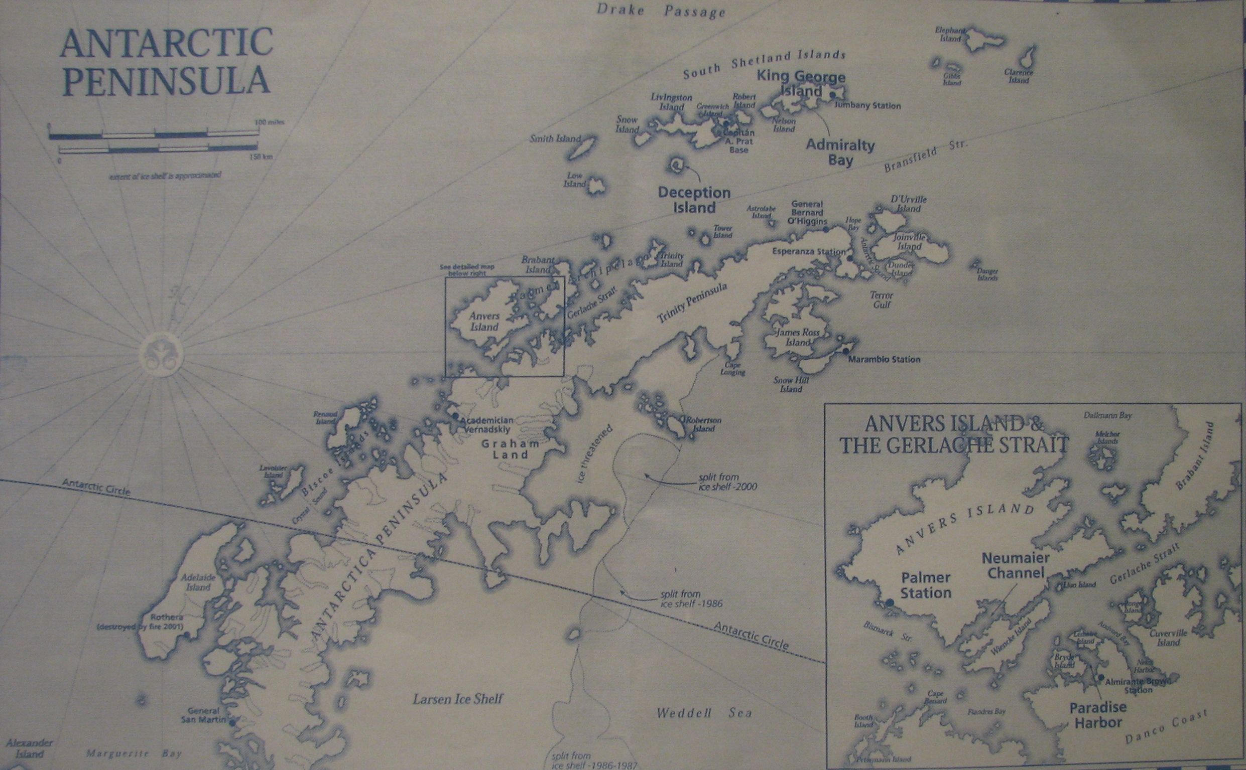
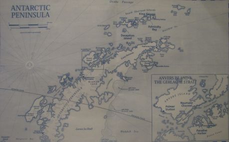 This is a photo
of a print map of the area that we are going to cruise. The map is a link to a larger version.
This is a photo
of a print map of the area that we are going to cruise. The map is a link to a larger version.
We start at Elephant Island in the upper right and then work our
way, over four days, around Anvers Island in the lower left. We will
not cross over the Antarctic Circle before we head north across the
Drake Passage to Ushuaia. At least, that is the plan. The weather can
change anything in the plan.
 Today, we did a double pass of Elephant
Island so that passengers on both sides of the ship who elected to stay
in the rooms could see it. There was a whale and a bunch of penguins
near the ship, but I only got video, no stills.
Today, we did a double pass of Elephant
Island so that passengers on both sides of the ship who elected to stay
in the rooms could see it. There was a whale and a bunch of penguins
near the ship, but I only got video, no stills.
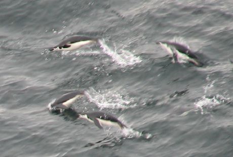
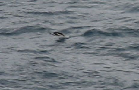 However, Sandy
was on a lower deck and closer to the action so she got some better
video. I've extracted a frame from the video which is also a link to a 10 second or so movie
of several penguins jumping from the water.
However, Sandy
was on a lower deck and closer to the action so she got some better
video. I've extracted a frame from the video which is also a link to a 10 second or so movie
of several penguins jumping from the water.
 By the time we went up to a
late lunch, it was visibly snowing right on the ship. We sat at lunch
with a lecturer, a Dr. Bernard Stonehouse. He said that the weather is
typically worse here than further south. Although it will probably get
colder, it is usually drier.
By the time we went up to a
late lunch, it was visibly snowing right on the ship. We sat at lunch
with a lecturer, a Dr. Bernard Stonehouse. He said that the weather is
typically worse here than further south. Although it will probably get
colder, it is usually drier.
Day 10, Wednesday Jan 16, 2008 about 0930 GMT-2, Iceberg Alley,
about 63° South, about 30°F
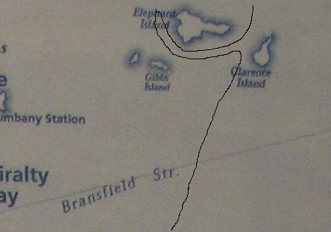
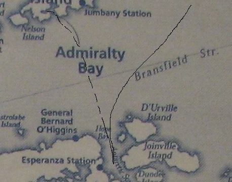 Early this morning, we were supposed to
go to Esperanza Station but the captain turned us back before we got
there. The wind was too strong for the width of the passage we were in
considering the profusion of icebergs. The passage between the tip of
the Antarctic Peninsula and Joinville Island is called "Iceberg Alley"
because the place is littered with them. We got on deck at about 0730
and the ship had already turned around. We are headed back across the
Bransfield Strait toward Admiralty Bay. We should get there by mid
afternoon. The dotted line is my estimate of our planned course.
Early this morning, we were supposed to
go to Esperanza Station but the captain turned us back before we got
there. The wind was too strong for the width of the passage we were in
considering the profusion of icebergs. The passage between the tip of
the Antarctic Peninsula and Joinville Island is called "Iceberg Alley"
because the place is littered with them. We got on deck at about 0730
and the ship had already turned around. We are headed back across the
Bransfield Strait toward Admiralty Bay. We should get there by mid
afternoon. The dotted line is my estimate of our planned course.
 The route to Esperanza Station is called
Iceberg Alley for good reason. It is littered with icebergs, some of
them large enough to be grounded in the 700' deep channel, however,
this is a smaller one. Due to it's irregular shape, it probably calved
from a glacier.
The route to Esperanza Station is called
Iceberg Alley for good reason. It is littered with icebergs, some of
them large enough to be grounded in the 700' deep channel, however,
this is a smaller one. Due to it's irregular shape, it probably calved
from a glacier.
 This flat top one has broken off an ice sheet.
The individual layers of compressed ice can be seen in the broken
side.
This flat top one has broken off an ice sheet.
The individual layers of compressed ice can be seen in the broken
side.
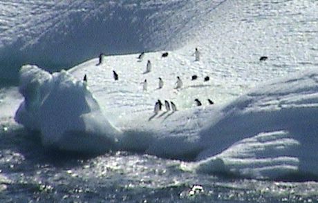
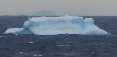 This one is fairly distant from the ship, it
has a red stain and some little black dots. The dots are penguins, they
will climb up on any iceberg with a sufficiently flat access to allow
them to climb on. The red stain is algae. It grows right on the ice
when sufficient nutrients are present. In this case, the nutrients are
penguin guano and a little wind blown dust.
This one is fairly distant from the ship, it
has a red stain and some little black dots. The dots are penguins, they
will climb up on any iceberg with a sufficiently flat access to allow
them to climb on. The red stain is algae. It grows right on the ice
when sufficient nutrients are present. In this case, the nutrients are
penguin guano and a little wind blown dust.
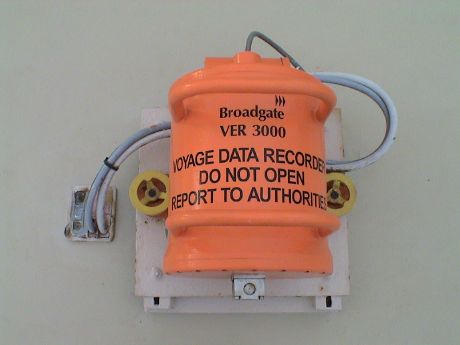 We were taking those pictures from the platform
on top of the bridge. This platform has normally been blocked off. On
the platform is a data recorder that is designed to separate from the
ship should it sink. The cabling goes right down to the systems on the
bridge.
We were taking those pictures from the platform
on top of the bridge. This platform has normally been blocked off. On
the platform is a data recorder that is designed to separate from the
ship should it sink. The cabling goes right down to the systems on the
bridge.
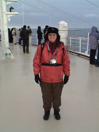 Sandy was bundled up pretty well. The air
temperature was about 30°F, but it was windy, up to 45 mph. The
wind chill was significant. She has a wool Russian had, an outer jacket
that she got in New Zealand, a Polartec and long underwear underneath
her cargo pants. Her light gloves are the same as mine, we found them
in ChristChurch New Zealand. They are made of a Polartec material and
are quite warm considering their weight and flexibility.
Sandy was bundled up pretty well. The air
temperature was about 30°F, but it was windy, up to 45 mph. The
wind chill was significant. She has a wool Russian had, an outer jacket
that she got in New Zealand, a Polartec and long underwear underneath
her cargo pants. Her light gloves are the same as mine, we found them
in ChristChurch New Zealand. They are made of a Polartec material and
are quite warm considering their weight and flexibility.
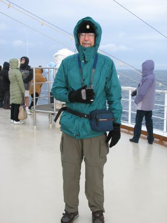 I was bundled up pretty well too. However,
in the wind, I felt a little cold on my upper body and legs. My hands
would have become cold too if I stayed up there for more than an hour
as I on only the light Polartec gloves. I have heavier ski gloves, but
when wearing them, I can hardly work the camera at all.
I was bundled up pretty well too. However,
in the wind, I felt a little cold on my upper body and legs. My hands
would have become cold too if I stayed up there for more than an hour
as I on only the light Polartec gloves. I have heavier ski gloves, but
when wearing them, I can hardly work the camera at all.
Sandy and I went in to get breakfast at about 0830 and then I wanted
to try another layer of clothing because I wasn't quite warm enough
with what I was wearing in the picture. I went back to the room and put
on another layer and went for a mile long walk on the Sports Deck, deck
16. I was wearing the same Thinsulate insulated light boots and
ordinary socks. My feet were quite warm. I put on two pair of thermal
underwear lowers instead of just one, one was a thermal weave of a
synthetic material and another of thin wool and then my lightweight
cargo pants. My legs were a little cool, but it was fine. I also had on
my Thinsulate insulated hooded rain jacket, an added Polartec fleece
jacket, my lined and Thinsulate insulated flannel shirt and a tee
shirt. I overdid the top part, I was too warm in the 30°F air, but
there was a 30+ knot wind in places and I was still ok. On my head I
had a simulated fur Russian hat and the rain jacket hood. I was fine
there too. On my hands, I had a pair of heavy ski gloves instead of the
lighter ones in the picture. My hands were overly warm. It looks like
dressing for the temperature is going to take some fine tuning.
Update, Day 10, Wednesday Jan 16, 2008 about 1630 GMT-2, Admiralty
Bay, about 62° South, about 32°F
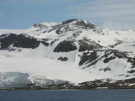 This afternoon we sailed into Admiralty Bay on
King George Island. There is a Polish research station located in the
bay. I was pretty cold and dreary when we first pulled in, but after a
little bit, the clouds parted, the sun came out brightly and it began
to feel quite warm, even though the air temperature was just freezing.
This whole area has a summertime average still air temperature of about
freezing, pretty warm by mainland Antarctica standards.
This afternoon we sailed into Admiralty Bay on
King George Island. There is a Polish research station located in the
bay. I was pretty cold and dreary when we first pulled in, but after a
little bit, the clouds parted, the sun came out brightly and it began
to feel quite warm, even though the air temperature was just freezing.
This whole area has a summertime average still air temperature of about
freezing, pretty warm by mainland Antarctica standards.
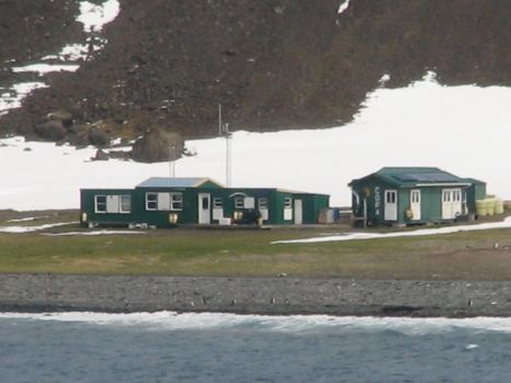 The first buildings we saw at a distance were
these huts along the shore. This is a summer only US station, commonly
called Copacabana, that sits in a site of special scientific interest
and does not accept visitors.
The first buildings we saw at a distance were
these huts along the shore. This is a summer only US station, commonly
called Copacabana, that sits in a site of special scientific interest
and does not accept visitors.
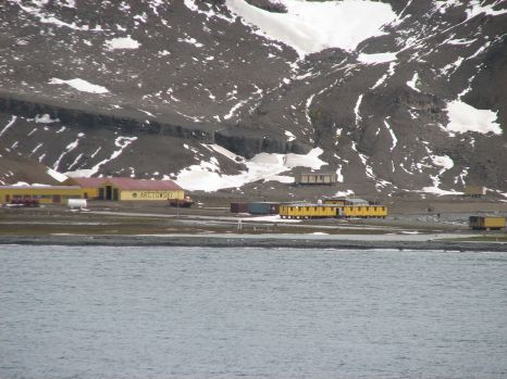 This is the Polish station proper, it's been
here for 20 years and is manned all year around, about 70 inhabitants
in summer and 20 in winter.
This is the Polish station proper, it's been
here for 20 years and is manned all year around, about 70 inhabitants
in summer and 20 in winter.
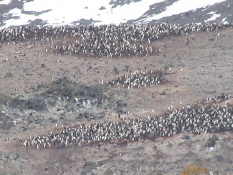 There were penguin colonies all around. I
figure that there were at least 10,000 penguins in this local area. We
were at least a mile off shore, but when the wind was right, we could
smell them.
There were penguin colonies all around. I
figure that there were at least 10,000 penguins in this local area. We
were at least a mile off shore, but when the wind was right, we could
smell them.
 There were a couple of
whales feeding in the bay. They appeared to be a mother and calf. We
saw them surface, blow a few times and then dive several times. The
photo is a link to a short movie of
a final breath and a dive.
There were a couple of
whales feeding in the bay. They appeared to be a mother and calf. We
saw them surface, blow a few times and then dive several times. The
photo is a link to a short movie of
a final breath and a dive.
 This the portion of the route that we will
take overnight. We will be traveling in the Bransfield Strait southwest
toward the Gerlache Strait. The plan is to double back from Anvers
Island along this route but we'll be stopping at Deception Island
before we head back north toward Ushuaia.
This the portion of the route that we will
take overnight. We will be traveling in the Bransfield Strait southwest
toward the Gerlache Strait. The plan is to double back from Anvers
Island along this route but we'll be stopping at Deception Island
before we head back north toward Ushuaia.
Day 11, Thursday Jan 17, 2008 about 1700 GMT-2, Gerlache Strait,
about 64° South, about 34°F
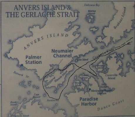 This is an approximate plot of our course
today. There is a cruise plan map posted on deck 14, but it is the
plan, not the actual. We deviated today because we didn't go far into
Flandres Bay because there were too many icebergs. Instead, the captain
took us part way down Andvard Bay after we got out of the Neumaier
Channel.
This is an approximate plot of our course
today. There is a cruise plan map posted on deck 14, but it is the
plan, not the actual. We deviated today because we didn't go far into
Flandres Bay because there were too many icebergs. Instead, the captain
took us part way down Andvard Bay after we got out of the Neumaier
Channel.
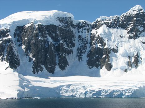
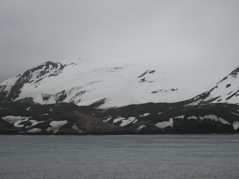
 The Gerlache Strait is lined with mountains
like this one. Where the rock isn't vertical, or nearly so, it's
covered in snow and ice. The ice cliffs at the water's edge are about
100 feet high. The strait itself is littered with icebergs, mostly
small ones so that the captain was weaving back and forth to avoid the
biggest of them. It is clear that he had the stabilizers pulled in too
as we were rolling a little. There is no point in whacking one on an
iceberg. Apparently, one had been damaged on a previous cruise and it
had been patched in Ft. Lauderdale.
The Gerlache Strait is lined with mountains
like this one. Where the rock isn't vertical, or nearly so, it's
covered in snow and ice. The ice cliffs at the water's edge are about
100 feet high. The strait itself is littered with icebergs, mostly
small ones so that the captain was weaving back and forth to avoid the
biggest of them. It is clear that he had the stabilizers pulled in too
as we were rolling a little. There is no point in whacking one on an
iceberg. Apparently, one had been damaged on a previous cruise and it
had been patched in Ft. Lauderdale.
 Some of the icebergs in Gerlache Strait were
kind of large. This one was very oddly carved by the wind and sea.
Some of the icebergs in Gerlache Strait were
kind of large. This one was very oddly carved by the wind and sea.
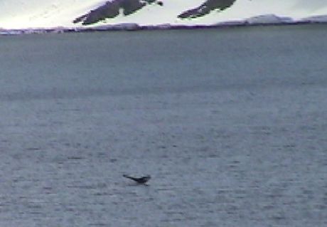
 I caught a view of a bunch of penguins on a
small iceberg in the strait. I can't quite tell from the photo which
kind the are, but they are most likely "chinstrap" penguins.
I caught a view of a bunch of penguins on a
small iceberg in the strait. I can't quite tell from the photo which
kind the are, but they are most likely "chinstrap" penguins.
The cruise plot plan showed us going to the south end of Flandres
Bay to the Neumaier Glacier. However, there was too much ice there. If
we had gone there, we would have crossed the 65th parallel, as is we
made it to only 64° 56 min south.
 As we turned into the Neumaier
Channel, we found more rock faces like in Gerlache Strait. The weather
in Gerlache Strait had been sunny with an air temperature of about
34°F, but it was intermittently windy. Without the wind, it was
quite pleasant. In a windy spot, it got really cold. I tended to move
around a lot to places that were shielded from the wind. In the
Neumaier channel, the wind virtually died and it was as nice as could
be expected. The naturalist, Dr. Stonehouse, was providing commentary
from the bridge. He had been here many times and he said that this was
by far the nicest day that he had ever seen. I'd have to agree that the
weather and sea conditions were excellent. It's so smooth right now
that we cannot tell that the ship is moving. We had only one night of
rough weather, the 2nd of the cruise, and another night with some
pitch. Other than that, the sea has been mostly dead calm.
As we turned into the Neumaier
Channel, we found more rock faces like in Gerlache Strait. The weather
in Gerlache Strait had been sunny with an air temperature of about
34°F, but it was intermittently windy. Without the wind, it was
quite pleasant. In a windy spot, it got really cold. I tended to move
around a lot to places that were shielded from the wind. In the
Neumaier channel, the wind virtually died and it was as nice as could
be expected. The naturalist, Dr. Stonehouse, was providing commentary
from the bridge. He had been here many times and he said that this was
by far the nicest day that he had ever seen. I'd have to agree that the
weather and sea conditions were excellent. It's so smooth right now
that we cannot tell that the ship is moving. We had only one night of
rough weather, the 2nd of the cruise, and another night with some
pitch. Other than that, the sea has been mostly dead calm.
 For most of the time, Sandy and I had been
in different places on the ship so that we could get more than one
viewpoint. However, after lunch, she came topside. This is a view
inside the Neumaier Channel.
For most of the time, Sandy and I had been
in different places on the ship so that we could get more than one
viewpoint. However, after lunch, she came topside. This is a view
inside the Neumaier Channel.
 At
the eastern end of the Neumaier Channel, we came across this iceberg.
The angle of the sunlight provided striking colors. I am not used to
the midday sun being in the north, but since this is the middle of
summer and it was not long after noon, the sun was actually quite high.
I got a sun burn on my nose.
At
the eastern end of the Neumaier Channel, we came across this iceberg.
The angle of the sunlight provided striking colors. I am not used to
the midday sun being in the north, but since this is the middle of
summer and it was not long after noon, the sun was actually quite high.
I got a sun burn on my nose.
Update, Day 11, Thursday Jan 17, 2008 about 1900 GMT-2, Bransfield
Strait, about 64° South
I tried to upload the Day 11 stuff. We got a connection to the
internet, but the data rate sort of died after one picture uploaded.
Also we got an email from our daughter that indicated that some of the
Day 10 photos were no good. They work here so there was probably a bad
upload yesterday too. When we get a good internet connection again,
I'll upload the stuff that didn't make it before. Internet time is too
expensive to download the whole page here so that I can see what didn't
work.
Day 12, Friday Jan 18, 2008 about 0015 GMT-2, Bransfield Strait,
about 64° South
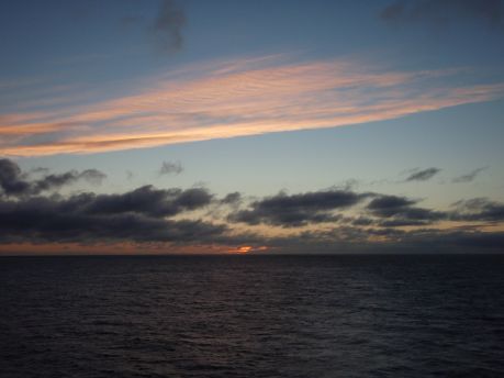 It's just past midnight again. We stayed up
late because this is the last sunset we will have this far south, at
least for this trip, and I was hungry again so we had another snack
right before midnight. The sun is still illuminating the clouds, it may
have still been up right at midnight. This picture is taken directly
astern.
It's just past midnight again. We stayed up
late because this is the last sunset we will have this far south, at
least for this trip, and I was hungry again so we had another snack
right before midnight. The sun is still illuminating the clouds, it may
have still been up right at midnight. This picture is taken directly
astern.
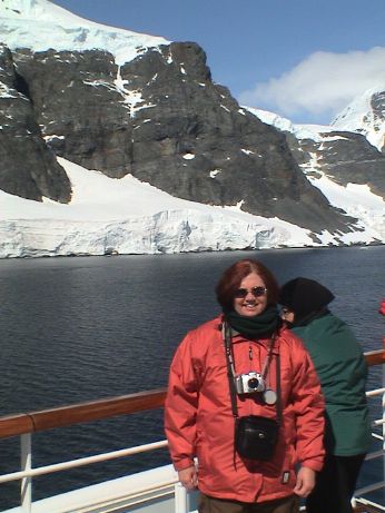
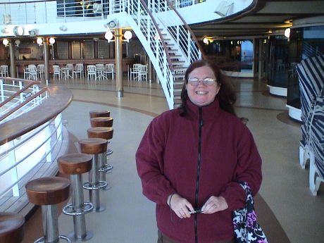 Then I turned around to take Sandy's
picture. There is still plenty of light for non-flash pictures.
Then I turned around to take Sandy's
picture. There is still plenty of light for non-flash pictures.
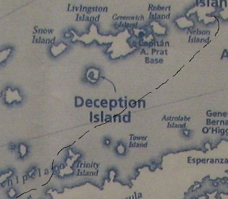
Update, Day 12, Friday Jan 18, 2008 about 1215 GMT-2, Deception
Island, about 63° South, about 33°F
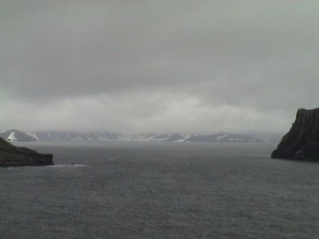
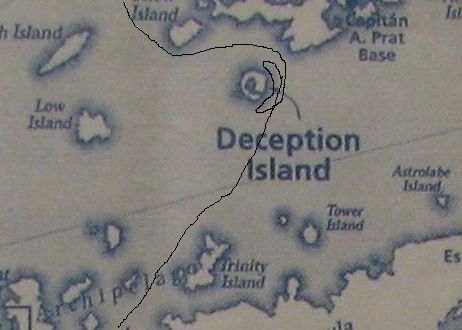 Today was a pass around Deception Island
and then we head north across the Drake Passage to Cape Horn. Deception
Island was named because unless you came at it from the southeast, it
would deceive you into believing that it was just an ordinary island.
In fact, it is one the most protected harbors in the Southern Ocean.
This is really a volcanic caldera with one opening to the sea. The
volcano has recently been active, in the last 100 years it has blown up
three times, each time destroying the facilities inside the bay.
Today was a pass around Deception Island
and then we head north across the Drake Passage to Cape Horn. Deception
Island was named because unless you came at it from the southeast, it
would deceive you into believing that it was just an ordinary island.
In fact, it is one the most protected harbors in the Southern Ocean.
This is really a volcanic caldera with one opening to the sea. The
volcano has recently been active, in the last 100 years it has blown up
three times, each time destroying the facilities inside the bay.
 From either the outside or the inside,
it is a pretty dreary place. I'm told that it is almost continually
overcast. The land is just volcanic ash covered in patches of snow.
From either the outside or the inside,
it is a pretty dreary place. I'm told that it is almost continually
overcast. The land is just volcanic ash covered in patches of snow.
We were up on Deck 16 for these photos. The humidity was high, about
85% and it was cold, near freezing. The wind was intermittent, but when
it was blowing, it was probably about 40 mph. This cold moist wind cuts
right through clothing and I got very cold before I had to come inside
to warm up.
 Bailey Head guards the eastern side of the
harbor entrance.
Bailey Head guards the eastern side of the
harbor entrance.
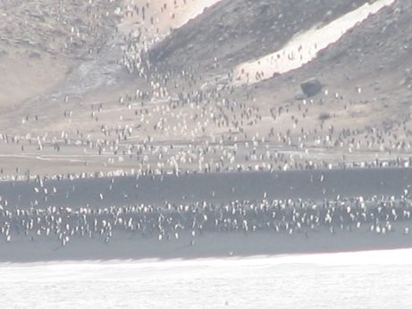 On the beach next to Bailey Head is a large
penguin colony, estimated at 200,000 birds.
On the beach next to Bailey Head is a large
penguin colony, estimated at 200,000 birds.
 All those penguins have to eat somewhere, and a
lot of them don't have to go far. There were penguins jumping from the
water almost continuously while were near Bailey Head. They guys jump
like dolphins, probably to get a quick look around.
All those penguins have to eat somewhere, and a
lot of them don't have to go far. There were penguins jumping from the
water almost continuously while were near Bailey Head. They guys jump
like dolphins, probably to get a quick look around.
 Deception Island harbor is quite
large, but the entrance is narrow and shallow. There is also a
shipwreck right in the middle of the passage. The Star Princess is much
too large to get in there, but there were three much smaller ships that
we did see go in. One was a 3 masted bark, built in 1911 and refitted
in 1986, the Europa, that did go in. The Europa does around the world
tours, much of it under as many as 30 sails.
Deception Island harbor is quite
large, but the entrance is narrow and shallow. There is also a
shipwreck right in the middle of the passage. The Star Princess is much
too large to get in there, but there were three much smaller ships that
we did see go in. One was a 3 masted bark, built in 1911 and refitted
in 1986, the Europa, that did go in. The Europa does around the world
tours, much of it under as many as 30 sails.
Update, Day 12, Friday Jan 18, 2008 about 1615 GMT-2, At Sea in the
Drake Passage
 After lunch, we did our laundry and then
uploaded new updates to these pages. I spend some time each day
collecting photos and video from three cameras, organizing them and
then determining which I am going to use on this page. Sandy does
pretty much the same thing, but in a somewhat different fashion. In any
event, after the domestic activities were done, we went to Deck 16 and
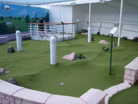
played a round of miniature golf. This course is weird enough with all
the bumps and lumps when the ship is still. We're doing it off Cape
Horn in the Drake Passage, although the seas are pretty flat right now.
We didn't keep score, but Sandy probably won because she didn't 10 putt
more than one hole.
After lunch, we did our laundry and then
uploaded new updates to these pages. I spend some time each day
collecting photos and video from three cameras, organizing them and
then determining which I am going to use on this page. Sandy does
pretty much the same thing, but in a somewhat different fashion. In any
event, after the domestic activities were done, we went to Deck 16 and
played a round of miniature golf. This course is weird enough with all
the bumps and lumps when the ship is still. We're doing it off Cape
Horn in the Drake Passage, although the seas are pretty flat right now.
We didn't keep score, but Sandy probably won because she didn't 10 putt
more than one hole.
We'll complete our journey across the Drake passage tomorrow
afternoon and then cruise by Cape Horn, the southern most part of the
Americas. Overnight, we will finish the trip to Ushuaia. We don't have
anything in particular planned for Ushuaia, but we will be docked so
that it will be easy to move on and off the ship.
Day 13, Saturday Jan 19, 2008 about 1230 GMT-2, At Sea in the Drake
Passage
 I went up on the Sports Deck to walk
off some calories and to test another combination of clothing in the
current weather condition. It is about 45°F with near gale force
winds, force 7 on the Beaufort Scale. I think that this is 35 mph. I
found that this particular combination of clothing worked well in this
combination of wind and temperature. The wind was blowing from the
starboard bow. One one corner of the walkway, the wind was blowing so
hard that I had to put my head down and push through it.
I went up on the Sports Deck to walk
off some calories and to test another combination of clothing in the
current weather condition. It is about 45°F with near gale force
winds, force 7 on the Beaufort Scale. I think that this is 35 mph. I
found that this particular combination of clothing worked well in this
combination of wind and temperature. The wind was blowing from the
starboard bow. One one corner of the walkway, the wind was blowing so
hard that I had to put my head down and push through it.
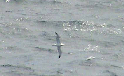
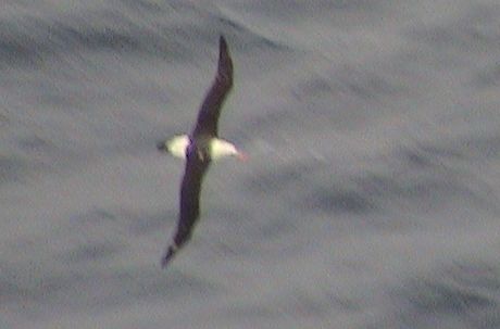
There was a black browed albatross cruising off the port side,
seemingly oblivious to the wind, however, it might have been using the
ship as a wind break. It was just looping back and forth just a foot or
two above the waves at times.
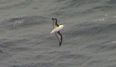 The black browed albatross is dark
on the top side with white underside the wings. They don't reach the
size of the wandering albatross which can have a wingspan up to 12 ft.
This one wasn't nearly that big.
The black browed albatross is dark
on the top side with white underside the wings. They don't reach the
size of the wandering albatross which can have a wingspan up to 12 ft.
This one wasn't nearly that big.
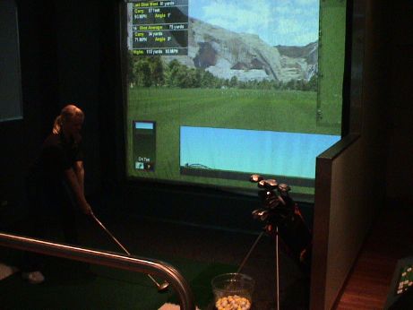 I'd
walked by this thing many times and never noticed the golf simulator on
Deck 16. It was open so I walked in to take a look. There were two
virtual driving ranges. The ball is tracked for speed and trajectory
and a computer calculates the range of the shot.
I'd
walked by this thing many times and never noticed the golf simulator on
Deck 16. It was open so I walked in to take a look. There were two
virtual driving ranges. The ball is tracked for speed and trajectory
and a computer calculates the range of the shot.
Update, Day 13, Saturday Jan 19, 2008 about 1900 GMT-2, Cape
Horn
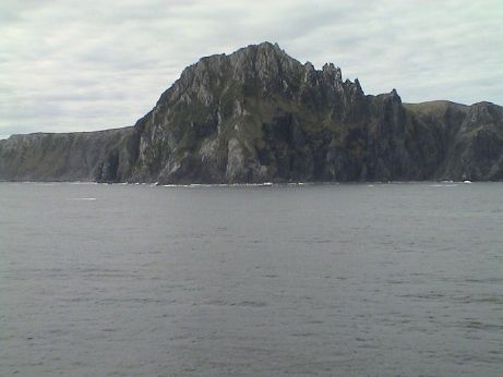 This is the famous Cape Horn. It is actually an
island, but it considered the southern tip of the Americas. The ship
approached the cape from the south east, picked up a pilot for the
passage through the Beagle Channel (which we will transit later this
evening) and then did a once around the island.
This is the famous Cape Horn. It is actually an
island, but it considered the southern tip of the Americas. The ship
approached the cape from the south east, picked up a pilot for the
passage through the Beagle Channel (which we will transit later this
evening) and then did a once around the island.
The wind blows hard here 350 days a year and it just blows some the
rest of the time. For us it was dead calm and there was almost no swell
either. The entire passage across one of the most fearsome parts of any
ocean was not significantly different that we have experienced on most
cruises.
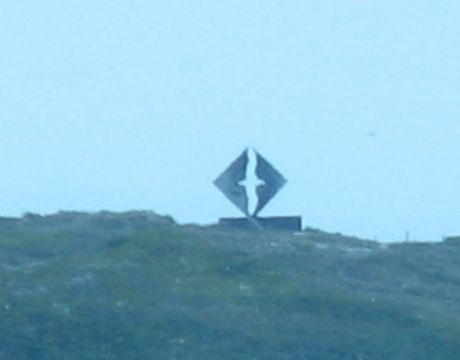 Cape Horn is claimed by Chile
which maintains a garrison here. At there base on the eastern tip of
the island, a sculpture of an albatross has been placed. This is cast
from two aluminum plates with the image of an albatross cut out. It
shows up well when viewed from the north where it contrasts with the
sky behind. From the south, off the cape, it tends to have mountains
behind it and it is much harder to see. This is a monument to the
sailors who lost their lives trying to sail around this cape.
Cape Horn is claimed by Chile
which maintains a garrison here. At there base on the eastern tip of
the island, a sculpture of an albatross has been placed. This is cast
from two aluminum plates with the image of an albatross cut out. It
shows up well when viewed from the north where it contrasts with the
sky behind. From the south, off the cape, it tends to have mountains
behind it and it is much harder to see. This is a monument to the
sailors who lost their lives trying to sail around this cape.
We bought a copy of Dr. Stonehouse's book, Antarctica from South
America. In it, he has the table of the Beaufort scale of wind
speed. I believe that we have not experienced wind speed beyond Force
9, this was in Iceberg Alley where we were forced to turn around. This
is the table that is presented on page 65 of the book.
This scale was invented in 1805 by Commander Francis Beaufort RN,
who wanted to set standards of wind force at sea. He had no means of
measuring wind speeds, so the original scale was based entirely on how
winds of different strengths affected sailing ships and disturbed the
sea surface. The scale has been used and developed over the years since
then, and still provides a very good way of estimating wind strength
from sea conditions.
| Conversions: |
knots (nautical miles per hour) to statute miles per hour |
multiply by 1.15 |
| knots to kilometers per hour |
multiply by 1.84 |
| knots to meters per second |
divide by 2 |
| meters to feet |
multiply by 3.3 |
| Beaufort No. |
Wind Speed (knots) |
Description of wind |
Sea No. |
Wave Height (m) |
Description of sea surface |
| 0 |
<1 |
Calm |
0 |
0 |
Sea is like a mirror |
| 1 |
1-3 |
Light air |
0 |
0 |
Ripples like scales, without foam crests |
| 2 |
4-6 |
Light breeze |
1 |
0-0.3 |
Small wavelets: crests appear glassy but do not
break |
| 3 |
7-10 |
Gentle breeze |
2 |
0.3-0.6 |
Large wavelets: crests begin to break. Foam glassy,
scattered white horses |
| 4 |
11-16 |
Moderate breeze |
3 |
0.6-1.2 |
Small waves becoming linger; fairly frequent white
horses |
| 5 |
17-21 |
Fresh breeze |
4 |
1.2-2.4 |
Moderate waves, lengthening: many white horses, slight
spray |
| 6 |
22-27 |
Strong breeze |
5 |
2.4-4 |
Large waves start to form: white foam crests extensive
everywhere, moderate spray |
| 7 |
28-33 |
Near gale |
6 |
4-6 |
Sea heaps up. White foam from wave tops blown in
streaks along wind: spindrift appears |
| 8 |
34-40 |
Fresh gale |
6 |
4-6 |
Moderately high waves, lengthening. Edges of crests
break into spindrift. Foam is blown in streaks along the wind |
| 9 |
41-47 |
Strong gale |
6 |
4-6 |
High waves: dense streaks of foam along the wind. Sea
begins to roll: spray limits visibility |
| 10 |
48-55 |
Storm |
7 |
6-9 |
Very high waves with long crests: large patches of
foam blown in streaks along wind. Sea rolls markedly, surface appears
white: spray limits visibility |
| 11 |
56-63 |
Violent storm |
8 |
9-14 |
Exceptionally high waves: sea covered with long
patches of foam: edges of wave crests blown into foam: spray limits
visibility |
| 12-17 |
>64 |
Hurricane |
9 |
>14 |
Air filled with foam and spray. Sea surface white with
driving spray: visibility seriously limited |
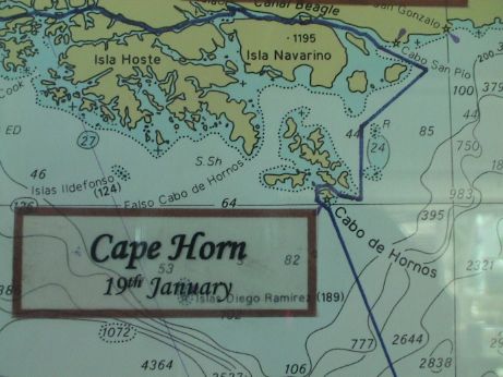 This is the posted chart of our passage around
Cape Horn, although it didn't come off exactly as shown. Instead of
looping around the west side, we started on the east side and went
counter clockwise all around the island and then proceeded north to the
Beagle Channel. The channel got it's name from Charles Darwin's ship,
the Beagle. We went through this section at about sundown. I didn't get
any pictures as I had already turned in for the night.
This is the posted chart of our passage around
Cape Horn, although it didn't come off exactly as shown. Instead of
looping around the west side, we started on the east side and went
counter clockwise all around the island and then proceeded north to the
Beagle Channel. The channel got it's name from Charles Darwin's ship,
the Beagle. We went through this section at about sundown. I didn't get
any pictures as I had already turned in for the night.
Day 14, Sunday Jan 20, 2008 about 1700 GMT-2, Ushuaia,
Argentina
 Ushuaia is shown on this chart, but the label is
underneath the lower left corner of the brown rectangle. The city is a
major jumping off point for Antarctic cruises on smaller ships as it
has a good harbor, an international airport and is closest to the
action.
Ushuaia is shown on this chart, but the label is
underneath the lower left corner of the brown rectangle. The city is a
major jumping off point for Antarctic cruises on smaller ships as it
has a good harbor, an international airport and is closest to the
action.
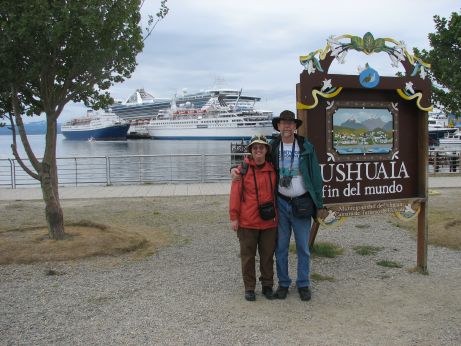 Ushuaia bills itself as the "end of the world."
You can see the Star Princess towering over two other medium sized
cruise ships at the wharf. As a shopping port, it was a bust because we
got in on Sunday morning and most of the town was locked up tight.
However, the weather was fairly nice, it was overcast but not cold,
about 60°F.
Ushuaia bills itself as the "end of the world."
You can see the Star Princess towering over two other medium sized
cruise ships at the wharf. As a shopping port, it was a bust because we
got in on Sunday morning and most of the town was locked up tight.
However, the weather was fairly nice, it was overcast but not cold,
about 60°F.
 The ship departed at 1630 for a cruise
through the rest of the Beagle Channel and then it winds it way up to
Punta Arenas in Chile. We have a penguin tour booked there.
The ship departed at 1630 for a cruise
through the rest of the Beagle Channel and then it winds it way up to
Punta Arenas in Chile. We have a penguin tour booked there.
About 15 min after the scheduled sailing time, one woman came
running down the dock, waving madly. She was probably the one that was
being paged on the PA system. I didn't think that they'd let here on
the ship as the gangway had already been raised, but an announcement
later indicated that everybody had made it on board. Often, if a
passenger is late, the ship will sail without them and they have to
make their own way to the next port of call.
Day 14, Sunday Jan 20, 2008 about 2030 GMT-2, Beagle Channel,
Chile
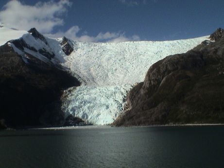 After we left Ushuaia, we headed west
again in the Beagle Channel past some glaciers on the north side of the
channel. This is the only one that still reaches the sea. The rest are
retreating, some severely.
After we left Ushuaia, we headed west
again in the Beagle Channel past some glaciers on the north side of the
channel. This is the only one that still reaches the sea. The rest are
retreating, some severely.
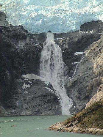 This one is melting at a prodigious rate,
there is a large cascade of meltwater pouring from an opening at the
end of the glacier.
This one is melting at a prodigious rate,
there is a large cascade of meltwater pouring from an opening at the
end of the glacier.
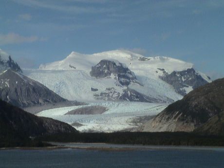 This was the largest glacier of this
group. According to the maps, it comes from an icefield that actually
spawns three glaciers.
This was the largest glacier of this
group. According to the maps, it comes from an icefield that actually
spawns three glaciers.
The wind was blowing pretty well the whole time in the channel. It
is blowing right down the channel, we are headed directly into it.
Almost everybody on deck was behind something to break the wind which I
estimated was at least 50 mph out on an open deck considering both the
wind and ship speed. They tell us that the wind in Punta Arenas can be
fearsome, regularly reaching 110 mph. This would be big news in most
places, these people are used to it.
It turns out that we did lose the internet connection in the Beagle
Channel because the channel is narrow and the mountains on the north
side are tall and steep which completely blocked the satellite link. It
worked pretty well in Antarctica with just some data rate problems in
spots. Although I didn't try it, we probably lost connectivity in the
Neumaier Channel due to the mountains of Anvers Island and may have had
problems in spots in the Gerlache Strait.
Day 15, Monday Jan 21, 2008 about 1930 GMT-3, Punta Arenas,
Chile
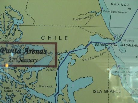 We arrived in Punta Arenas this morning at
0700, but we slept in to 0900. We have a tour in the afternoon which
meets on shore and there isn't much that we want to do in town so we
went in at about 1000 after a big breakfast.
We arrived in Punta Arenas this morning at
0700, but we slept in to 0900. We have a tour in the afternoon which
meets on shore and there isn't much that we want to do in town so we
went in at about 1000 after a big breakfast.
Punta Arenas means "sandy point." This spot on the Strait of
Magellan. This was a big port town servicing ships that went around
Cape Horn until the Panama Canal opened up in 1914. Then things dried
up considerably. The economy recovered after WWII based on the
discovery of oil in the region. This place is windy all the time.
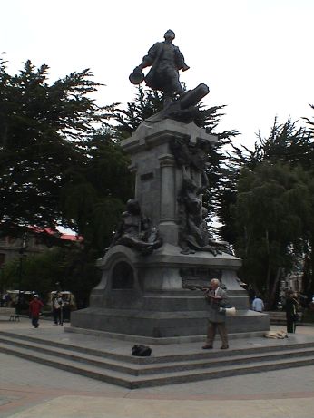 There is a large monument to Ferdinand
Magellan in a plaza right in the middle of town. When we got there, a
guy was prancing around the statue shouting through a bullhorn. I can't
understand much Spanish, but even I could tell that they guy was
predicting the end of the world.
There is a large monument to Ferdinand
Magellan in a plaza right in the middle of town. When we got there, a
guy was prancing around the statue shouting through a bullhorn. I can't
understand much Spanish, but even I could tell that they guy was
predicting the end of the world.
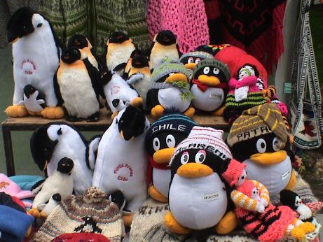 The plaza was ringed with vendor stalls. For
sale one could find penguin plush toys, penguin statues, all manner of
wool products and a wide selection of jewelry. Sandy bought a
refrigerator magnet.
The plaza was ringed with vendor stalls. For
sale one could find penguin plush toys, penguin statues, all manner of
wool products and a wide selection of jewelry. Sandy bought a
refrigerator magnet.
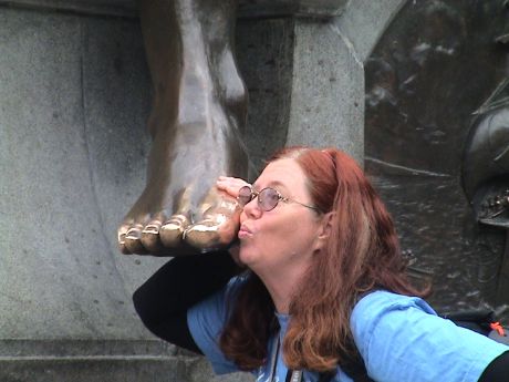 On one side of the Magellan
statue is a bronze of a Patagonian indian. It is said that if you rub
or kiss the indian's toe, you will return to Punta Arenas. We figured
that it couldn't hurt....
On one side of the Magellan
statue is a bronze of a Patagonian indian. It is said that if you rub
or kiss the indian's toe, you will return to Punta Arenas. We figured
that it couldn't hurt....
We hung around town for awhile got some lunch in a supermarket and
waited for our bus tour.
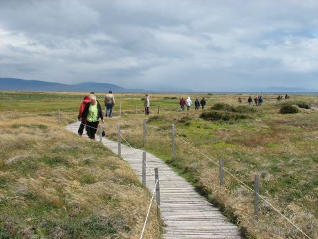 The tour was a bus ride way out a dirt road to
a Magellanic penguin colony. These were the same kind that we saw in
the Falkland Islands, However, we were able to get right down to the
beach and walk through the nesting colony itself on this wooden
walkway. The whole loop was about a mile.
The tour was a bus ride way out a dirt road to
a Magellanic penguin colony. These were the same kind that we saw in
the Falkland Islands, However, we were able to get right down to the
beach and walk through the nesting colony itself on this wooden
walkway. The whole loop was about a mile.
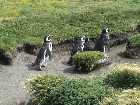 Unlike on the Falklands where the penguins had
to climb a steep hill to get to their nests, this area is almost flat.
The penguins appear to have picked a stream bed as a penguin freeway to
the beach. As these three were going down, two others were coming up.
The collision occurred in a section that was just one penguin wide, it
was interesting to see them climb all over each other trying to get by.
The adults both feed their chicks, they'll each go out a couple of
times a day to feed and bring back their catch which they will
regurgitate for the chicks.
Unlike on the Falklands where the penguins had
to climb a steep hill to get to their nests, this area is almost flat.
The penguins appear to have picked a stream bed as a penguin freeway to
the beach. As these three were going down, two others were coming up.
The collision occurred in a section that was just one penguin wide, it
was interesting to see them climb all over each other trying to get by.
The adults both feed their chicks, they'll each go out a couple of
times a day to feed and bring back their catch which they will
regurgitate for the chicks.
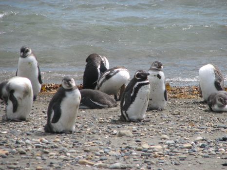 This combination of juvenile (brown or
gray) and adult (black and white) penguins are just lounging around on
the beach. This is where the largest concentration was. There was a
sort of a blind built right on the beach so that 30 people or so at a
time could take pictures without disturbing the birds too much.
This combination of juvenile (brown or
gray) and adult (black and white) penguins are just lounging around on
the beach. This is where the largest concentration was. There was a
sort of a blind built right on the beach so that 30 people or so at a
time could take pictures without disturbing the birds too much.
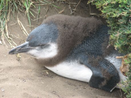 This is a juvenile penguin losing it's brown
feathers and replacing them with an adult coat. When this guy's coat is
done, he can go to sea. Adults molt every year too just after rearing
their chicks. They are stuck on shore for three weeks or so until their
new coat comes out.
This is a juvenile penguin losing it's brown
feathers and replacing them with an adult coat. When this guy's coat is
done, he can go to sea. Adults molt every year too just after rearing
their chicks. They are stuck on shore for three weeks or so until their
new coat comes out.
As the ship was readying to leave Punta Arenas, the wind came up to
Force 9 on the Beaufort scale at about 50 mph for a while during the
time that they were trying to bring the last of the tenders on board.
The ship pulled it's anchor and used the automatic positioning system
to turn the ship and hold it's position to block the wind so that the
tenders could unload safely.
Now we have three days at sea to get to Montevideo, Uruguay.
Day 16, Tuesday Jan 22, 2008 about 1700 GMT-3, At Sea
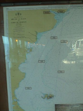 Today is the first of three sea days
to get to Montevideo. The temperature is in the mid 50's and the sea is
calm, winds are force 3 or less. The navigator has plotted a virtual
beeline from the exit of the Strait of Magellan to the Rio de la Plate
where both Montevideo and Buenos Aires are located.
Today is the first of three sea days
to get to Montevideo. The temperature is in the mid 50's and the sea is
calm, winds are force 3 or less. The navigator has plotted a virtual
beeline from the exit of the Strait of Magellan to the Rio de la Plate
where both Montevideo and Buenos Aires are located.
We went to a lecture by Dr. Stonehouse about ice. Ice is a big deal
in the polar regions and lots of folks pay lots of attention to it as
ice conditions can make the difference between life and death. Later in
the afternoon, Captain Bob Parsons USCG Retired, spoke about the Coast
Guard, ice breaker operations in the Antarctic and the role of the "ice
navigator" aboard the ship. Antarctic treaties require that all ships
that ply these waters have a navigator on board who is experienced in
these waters. Our ship's captain has been here once before, that
doesn't count. We needed a special ice navigator or ice pilot and Bob
Parsons has that kind of experience. When the winds were blowing force
9 (55 mph or so) in the Antarctic Sound (Iceberg Alley), Bob and the
captain determined that there wasn't enough room to maneuver between
the icebergs, some of which could have been moving in that wind, so we
didn't make it to Esperanza Station. Instead, we turned around where
there was still room.
The next two days will be laid back as well.
Day 17, Wednesday Jan 23, 2008 about 1900 GMT-3, At Sea
We slept in today, only getting up in time for breakfast an a
lecture at 1000 by the navigator, Mario Tani, about the operation of
the ship. I learned that the "gross" tonnage of the ship is a
calculation based on the ship's volume, not the amount of water it
displaces. The actual displacement is much less, only 71,763 tons. The
gross tonnage is an inflated number because the ship is "fluffed" up
with lots in interior volume above the water line. The thing is still
bigger than an Iowa class battleship.
The fog horn had been sounding most of the morning as we were
traveling in fog. The sea was calm and the wind was a gentle breeze but
visibility was poor.
We attended a cocktail party for the "Captain's Circle." This is
sort of a benefits club for frequent cruisers. They were serving free
(weak) drinks and snacks. At the end, they raffled off two bottles of
Korbel, we won one. This is interesting because I don't drink so we had
it sent downstairs to share with a completely arbitrary set of dinner
companions. At least they appreciated it.
It has warmed up considerably. I went out for a walk and had to shed
the jacket, hat and gloves. It was tee shirt weather again.
Day 18, Thursday Jan 24, 2008 about 1130 GMT-2, At Sea
Last night, we split the bottle of champagne, I sipped some are
realized again that I don't particularly care for it. Sandy had one
glass but it made her ill later in the evening. We didn't finish the
bottle at our table, but I don't think that we'll be claiming the
rest.
After we went to bed, there was a knock at the door. The room
steward had a pile of forms for us. We have a customs form for Uruguay,
our luggage tags and instructions for disembarkation, and our tour
tickets for a city and tango tour after the cruise. At the end of the
tour, we'll be returning to the terminal to claim our luggage and then
we have to make our own way back to the hotel as our hotel isn't one of
the ones for which Princess offers a luggage transfer.
Our passage last night was smooth and uneventful and the navigator
expects pretty much of the same for the rest of this leg to
Montevideo.
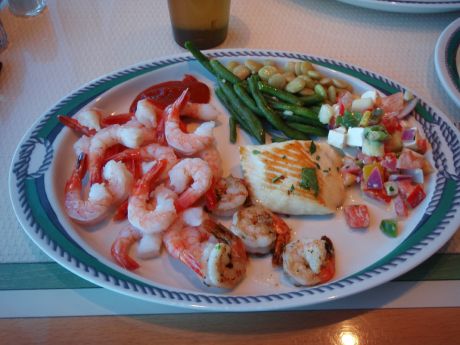 Dinner dress tonight was formal, but we didn't
bring any formal dress to lighten the load in our baggage. We had
dinner in the cafe instead. This is a pretty normal dinner. They don't
have shrimp like this every night, but tonight, shrimp was cheap. There
is always several kinds of seafood. I didn't even make a dent in what
they had. The shrimp boat was about 4 ft long by 2 ft wide, full of
shrimp. There was another identical one in the cafe on the other side
too.
Dinner dress tonight was formal, but we didn't
bring any formal dress to lighten the load in our baggage. We had
dinner in the cafe instead. This is a pretty normal dinner. They don't
have shrimp like this every night, but tonight, shrimp was cheap. There
is always several kinds of seafood. I didn't even make a dent in what
they had. The shrimp boat was about 4 ft long by 2 ft wide, full of
shrimp. There was another identical one in the cafe on the other side
too.
The big pile is shrimp cocktail. There is also grilled shrimp, some
halibut, green and lima beans and some greek salad. Off to the side is
a plate of fresh pineapple for dessert. I've been eating pineapple with
virtually every meal, sometimes as much as half a small pineapple's
worth each time.
We also did our laundry. Just as a note, we have found on more than
one cruise that there is often a wait for a washer except during
dinner. During formal dinners, the place is usually deserted. If you
need to wash clothes, dinner time is the time to do it.
Update, Day 18, Thursday Jan 24, 2008 about 2200 GMT-2, At Sea
We slept in really late this morning and didn't even get breakfast.
Therefore, I could rationalize a 2nd dinner. I intended to just get a
snack but it turned into another full meal. I didn't catch a photo, but
I had more of the grilled shrimp, greek salad and pineapple. In
addition, I had a slab of Beef Wellington, a curry vegetable samosa and
a few cubes of pepper cheese. It was all good. I am sure going to miss
the food on this ship, it has been pretty good all around.
I really haven't commented much on the decor of this ship. It is
much nicer than the Regal Princess, which I though was pretty plain.
There is lots of wood paneling and gold accents. The is lots of art
around but it tends to fade into the background because it isn't
exceptional, unlike on the Statendam which was a virtual floating
museum and antique art gallery. The ship is kept in very good condition
and most things seemed to work as expected.
The overall size of the ship made for lots of walking and lots of
stair climbing as I avoided the elevators unless I was planning on
climbing 10 flights. Smaller ships are a little easier to get around
in.
I think that the sound insulation between rooms isn't quite as good
as on other ships that I have been on. A passenger next door had a
serious cough and we could hear that pretty well.
There are bars everywhere on this ship, but smoking is allowed in
only one of them which is far away from everything else. Smoking is
also allowed down one side of the outside portion of deck 14, so we
learned to walk down the other side, which was the side our room was on
anyway. They did a good job of keeping the smoke away from passengers
that weren't actually smoking.
The Italian restaurant on this ship probably had very good food, but
it had a $20 cover charge per head, which I thought was a little steep.
On the Regal Princess, the most excellent Italian bistro was no extra
charge.
The ship side of the Princess cruises seemed well organized and the
service was excellent all around with every member of the crew being
helpful and responsive. When we finished with our plates in the cafe,
the plates would have a half life of about 10 seconds. Somebody would
come by and scoop them up almost immediately.
However, the shoreside part of the Princess organization could use
some help. Shoreside service was chaotic at best and accurate answers
to questions were hard to come by. We were misled more than once and I
got suspicious of any information that I got from the shoreside
support. Even our travel agent was having difficulties when she was
trying to book the cruise.
The internet service was expensive, but this is pretty normal too.
Wireless only access, which I prefer anyway, was $0.50/min on an al a
carte basis. Holland's cost was typically $0.40/min, but that had to be
purchased in $100 chunks. The satellite link was reasonable for a ship,
the data rates, when it did work, seemed to be a little better than I
have experienced before, but not by a large amount. There were still
outages, but it the fact that it worked at all at 64° south was
pretty amazing. It only stopped working completely when there were
obvious blockages, like mountains, nearby to the north. However, the
wireless didn't work in the cabins. I had to walk down four flights of
stairs to get to a place with wireless access. There was also no cell
phone repeater on board. That was pretty expensive on the Statendam at
a $2/min roaming charge, but at least it worked.
The beverage service is a little more limited than on the Holland
America ships. Alcoholic beverages or anything for that matter, were
very expensive, but this is pretty normal for cruise ships. I don't
drink anything with alcohol, caffeine or artificial sweeteners so that
limits my choices pretty much to ice water some sodas and fruit juice.
However, juice is only available at breakfast, and then only orange and
cranberry, both of which are fine, but I'd like a little better
selection. Sodas were are very expensive however, there is an unlimited
soda card available for purchase. I survived on my favorite beverage
anyway, ice water. Also, ice cream is available with dessert at the sit
down dinners or for purchase during the day from the ice cream bar. On
Holland, ice cream was available free at least for most of the
afternoon and evening.
I made a comment to the hotel manager about the trash cans in the
public restrooms. The ones that were there were so far from the door,
it was hard to use a paper towel to pull open the door, ditch the towel
and then get back to the door before it closed. I suggested that they
put a trash can near the door. The next time I went to wash my hands
before a meal, the cans were there.
Day 19, Friday Jan 25, 2008 about 1600 GMT-2, Montevideo,
Uruguay
 We visited Montevideo today.
This was just another old Spanish town, really nothing stood out.
We visited Montevideo today.
This was just another old Spanish town, really nothing stood out.
This was obviously somebody important because his statue is right in
the middle of town, but we couldn't figure out who he was. The town is
a contrast, some of it is upscale and pretty nice, most of what we saw
was pretty shabby with really bad sidewalks and lots of run down
buildings.
 We were warned on the ship about
pickpockets in this town, there were police everywhere. Still, I didn't
feel very comfortable there.
We were warned on the ship about
pickpockets in this town, there were police everywhere. Still, I didn't
feel very comfortable there.
 There were some vendor stalls in
the Plaza Constitucion. These were unlike any others we have seen in
our travels. They weren't selling trinkets like normal street vendors.
It seemed to be a garage sale instead. However, Sandy did find some
pretty nice refrigerator magnets with prints of 30's era posters or
stamps on them.
There were some vendor stalls in
the Plaza Constitucion. These were unlike any others we have seen in
our travels. They weren't selling trinkets like normal street vendors.
It seemed to be a garage sale instead. However, Sandy did find some
pretty nice refrigerator magnets with prints of 30's era posters or
stamps on them.
 Montevideo's trash collection
system seems a little dated, these guys were all over the city.
Montevideo's trash collection
system seems a little dated, these guys were all over the city.
We only spent two hours shoreside until we decided that we had seen
enough and we wanted to reduce our exposure to being robbed.
Unfortunately, we the only way back to the ship is via a four block
wide section of less than desirable neighborhoods. However, we made it
without incident.
We had lunch in the cafe and then I settled down to organize and
edit video. Since I have the PowerBook with me an sufficient external
disk space to work, I can do my video editing in almost real time as
time permits and while I still remember exactly what happened. On the
last cruise to New Zealand, I had 6 hours of video to work with after
we got back and I spent a few days grinding through it. This time, all
the movies will be done by the time I get home and all I'll have to do
is to back the projects up to DVD-R and actually compose the viewable
DVDs. Building the DVD takes only a few minutes each, but many hours to
render and burn. I'll have about two full DVD's worth.
Day 20, Saturday Jan 26, 2008 about 1900 GMT-2, Buenos Aires
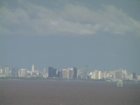 This is Buenos Aires from about 10 miles down
the Rio de la Plate. We were supposed to be off the ship by then, but
there was a delay. The captain came on the PA system at about 0700 and
said we were resting at anchor 28 miles down the Rio de la Plate from
Buenos Aires due to high winds in the harbor and therefore we would be
late getting in. About a half hour later, he said that he could begin
to make way and our ETA was 1000. All ship's schedules are pushed back
by two hours. We were all packed up, had cleared our cabin and waited
in Tequila's near the theatre for our call time for out tour. Since we
fly out tomorrow and we have a hotel reservation for tonight, this
delay was not a big deal for us. Those that have booked tight flight
schedules, however, may have some difficulty.
This is Buenos Aires from about 10 miles down
the Rio de la Plate. We were supposed to be off the ship by then, but
there was a delay. The captain came on the PA system at about 0700 and
said we were resting at anchor 28 miles down the Rio de la Plate from
Buenos Aires due to high winds in the harbor and therefore we would be
late getting in. About a half hour later, he said that he could begin
to make way and our ETA was 1000. All ship's schedules are pushed back
by two hours. We were all packed up, had cleared our cabin and waited
in Tequila's near the theatre for our call time for out tour. Since we
fly out tomorrow and we have a hotel reservation for tonight, this
delay was not a big deal for us. Those that have booked tight flight
schedules, however, may have some difficulty.
Two hours late, we were called to the Princess Theatre, to wait our
turn to get off the ship. It took about another half hour, but we were
called and filed out to our waiting buses. So ends the cruise portion
of the trip.
 We were
supposed to go on a city tour and then to the tango show with lunch,
but we were so late that they switched it around. There was a singer
named Carlo Gardel here in Buenos Aries who, while he lived, was as big
here as Frank Sinatra was in the US. The tango club was named after him
and his statue is on a pedestal out front. The lunch was excellent, an
appetizer, a very good Angus beef steak and a high calorie dessert. I
am not particularly into the Tango, but Sandy wanted to see the show.
These were really excellent dancers accompanied by live tango music
performed by equally excellent musicians. The show lasted a little over
an our and was quite entertaining. The style of Tango in the show is
"export Tango" which is not the style typically found in the clubs for
the locals. The photo is a link to a movie of a particularly acrobatic portion of the
show.
We were
supposed to go on a city tour and then to the tango show with lunch,
but we were so late that they switched it around. There was a singer
named Carlo Gardel here in Buenos Aries who, while he lived, was as big
here as Frank Sinatra was in the US. The tango club was named after him
and his statue is on a pedestal out front. The lunch was excellent, an
appetizer, a very good Angus beef steak and a high calorie dessert. I
am not particularly into the Tango, but Sandy wanted to see the show.
These were really excellent dancers accompanied by live tango music
performed by equally excellent musicians. The show lasted a little over
an our and was quite entertaining. The style of Tango in the show is
"export Tango" which is not the style typically found in the clubs for
the locals. The photo is a link to a movie of a particularly acrobatic portion of the
show.
 The city tour took us all over the
waterfront portion of the city were most of the interesting monuments
are. We had to drive by the "pink house," (aka the Casa Rosada of Evita
fame). This photo shows the two balconies where Juan and Evita Peron
addressed the citizens of Buenos Aires. This building is still holds
the office of the Argentine president.
The city tour took us all over the
waterfront portion of the city were most of the interesting monuments
are. We had to drive by the "pink house," (aka the Casa Rosada of Evita
fame). This photo shows the two balconies where Juan and Evita Peron
addressed the citizens of Buenos Aires. This building is still holds
the office of the Argentine president.
We then dropped most of the passengers off at their hotels. Ours
wasn't on the Princess list so we were taken back to the terminal to
claim our baggage. The cab fare back to the PanAmericano was 4 times
what it was getting there, but we were warned. Still it was only $15
US.
We got a "Presidencial Suite" again, this time on the 5th floor. It
would appear that there is one such room per floor. Sandy crashed, I
went out for victuals. I got a very large ham and cheese sandwich, a
meat pie kind of thing and two 1.5 liter bottles of soda for about 19
pesos, or a little over $6US at some little shops around the corner
from the hotel.
While we were on the ship, we heard horror stories of street
robberies, one at gunpoint, right near this hotel and the city tour
guide sternly warned us not to carry anything that we couldn't afford
to loose. We have elected to stay in this time. We'll check out at noon
and get a cab to the airport and wait there for about 8 hours for our
flight.
Day 22, Monday Jan 28, 2008 about 1500 PST, Back Home
There is no entry for Day 21 because we were traveling all day and I
didn't fire up the computer. However, we did make it back home.
Yesterday, we elected to check out from the hotel at noon and go
directly to the airport via a cab. We just didn't want to mess with
Buenos Aires anymore due to crime worries. Since our flight was
scheduled to leave at 2150 this meant a very long wait at the
airport.
 One thing I did find there was a grapefruit soda
called Quatro Pomelo. This stuff is absolutely great, it is what Squirt
used to be so many moons ago when Squirt was sold in the swirly green
bottles. This is before Coca Cola bought the brand and changed the
formulation. However, this brand is also bottled by Coca Cola. They
should bring this stuff back to the US.
One thing I did find there was a grapefruit soda
called Quatro Pomelo. This stuff is absolutely great, it is what Squirt
used to be so many moons ago when Squirt was sold in the swirly green
bottles. This is before Coca Cola bought the brand and changed the
formulation. However, this brand is also bottled by Coca Cola. They
should bring this stuff back to the US.
 Ezeliza Airport in Buenos Aires (EZE) has
managed to outdo LAX for uncomfortable seats in the terminal. They were
cast metal with ridges across them right were a tender posterior would
be. That made sitting in them for any length of time a form of torture.
It was 1800 before American Airlines even opened up for check in. We
got through the process in a normal fashion and after paying our
departure tax of $18US/head, we moved through security and Argentine
immigration into the gate area. We had a good dinner there and then
waited for the on-time departure of our flight. As expected, I hardly
slept at all on the 11 hour overnight flight.
Ezeliza Airport in Buenos Aires (EZE) has
managed to outdo LAX for uncomfortable seats in the terminal. They were
cast metal with ridges across them right were a tender posterior would
be. That made sitting in them for any length of time a form of torture.
It was 1800 before American Airlines even opened up for check in. We
got through the process in a normal fashion and after paying our
departure tax of $18US/head, we moved through security and Argentine
immigration into the gate area. We had a good dinner there and then
waited for the on-time departure of our flight. As expected, I hardly
slept at all on the 11 hour overnight flight.
The flight experienced 150 mph headwinds the WHOLE way and even
though the captain put the pedal to the metal, we were late getting
into O'Hare. We hurried, as best we could, through US immigration and
customs, rechecked our bags and then transferred to another terminal.
There we passed through security again and were almost the last people
on the flight to LAX. This flight was uneventful. At LAX we took a cab
home to find Charlie, and a whole stack of mail. I took a shower, and
then crashed for a couple of hours. It'll take days to put our lives
back in order, but we've started that process already.
This page has been accessed times since Dec 5, 2007
© 2007-2008 George Schreyer
Created Dec 5, 2007
Last Updated January 27, 2008